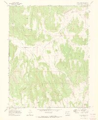
1969 Map of Bieser Creek
USGS Topo · Published 1973About this map
Coates Creek Sch stands as a focal point of rural life in this remote stretch of Mesa County during the late 1960s. The landscape is defined by the deep incisions of Kings Canyon and Toms Canyon, where water sources like Toms Canyon Spring and the curious landmark of Water Jugs were critical to local land use. In the northern reaches, the Dolores River cuts through the terrain, joined by tributaries including Little Bieser Creek and Bieser Creek. The transport network of the era was dominated by the D S Road and numerous jeep trails that navigated the complex drainages of Briar Canyon and Middle Canyon. Near the southern boundary, McGinley Spring and Nelson Creek indicate the continued importance of reliable water in this arid highland.
Find a feature on this map
22 named features on this map. Tap any name to fly to it.
Don’t see what you’re looking for? This feature index may not catch every label — zoom into the map to look around manually.
Map Details
Editions of this 1969 Bieser Creek Map
3 editions found
Other maps of this area

1885 · East Tavaputs
USGS Topo · 1:250,000

1885 · La Sal
USGS Topo · 1:250,000

1954 · Mt. Waas 1 NE
USGS Topo · 1:24,000

1954 · Mt. Waas 1 SE
USGS Topo · 1:24,000

1954 · Coates Creek
USGS Topo · 1:62,500

1956 · Westwater 4 SE
USGS Topo · 1:24,000

1956 · Moab
USGS Topo · 1:250,000

1956 · Grand Junction
USGS Topo · 1:250,000

1959 · Grand Junction
USGS Topo · 1:250,000

1959 · Moab
USGS Topo · 1:250,000