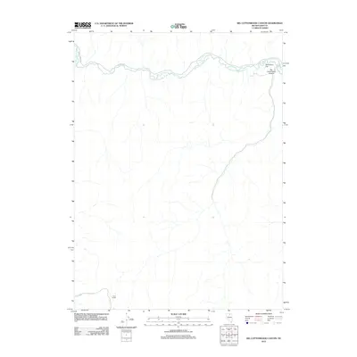
2012 Map of Big Cottonwood Canyon
USGS Topo · Published 2012About this map
The South Fork Owyhee River meanders across this Elko County landscape, defining the topography as it winds through the namesake Big Cottonwood Canyon. This 2012 survey illustrates a sparsely populated region where water and high-altitude terrain dictate the layout of the land. In the southern reaches of the map, Camp Divide serves as a lone point of settlement, situated near the headwaters of Dry Creek. The northern river corridor features Swimmers Flat, a distinct break in the canyon walls that highlights the importance of river access in this high desert environment. While most of the area remains undeveloped, infrastructure is represented by the path of Co RD 730, which follows the river's course in the northwest, providing a vital connection through this isolated Nevada terrain.
Find a feature on this map
6 named features on this map. Tap any name to fly to it.
Don’t see what you’re looking for? This feature index may not catch every label — zoom into the map to look around manually.
Map Details
Editions of this 2012 Big Cottonwood Canyon Map
This is the sole edition of this map. No revisions or reprints were ever made.
Other maps of this area

1955 · McDermitt
USGS Topo · 1:250,000

1956 · Tuscarora
USGS Topo · 1:62,500

1956 · Mt. Blitzen
USGS Topo · 1:62,500

1956 · Bull Run
USGS Topo · 1:62,500

1959 · McDermitt
USGS Topo · 1:250,000

1964 · Wilson Reservoir
USGS Topo · 1:62,500

1982 · Bull Run Mts
USGS Topo · 1:100,000

1982 · Tuscarora
USGS Topo · 1:100,000
1987 · Cottonwood Peak
USGS Topo · 1:24,000
1987 · Toe Jam Mountain
USGS Topo · 1:24,000