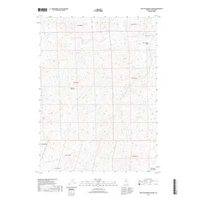
2018 Map of Big Cottonwood Canyon
USGS Topo · Published 2018About this map
Tuscarora Mountains anchor this high-elevation landscape in Elko County, where steep drainages and flat tablelands define the northeastern Nevada terrain. The area is dominated by the dramatic descent of Big Cottonwood Canyon as it carves through the mountains toward Swimmers Flat in the northeast corner of the quadrangle. This 2018 survey documents the remote watershed of the upper Dry Cr, which flows beneath the prominent peak of Dry Creek Mtn in the southern portion of the sheet. The map reveals a land primarily shaped by its hydrology and relief, with Cottonwood Creek Canyon providing a natural corridor through the rugged mountain range. Without the presence of developed towns or major highways, the map focuses on the precise contouring of these public lands, showing the network of minor roads and tracks that navigate the high-country peaks and valleys.
Find a feature on this map
13 named features on this map. Tap any name to fly to it.
Don’t see what you’re looking for? This feature index may not catch every label — zoom into the map to look around manually.
Map Details
Editions of this 2018 Big Cottonwood Canyon Map
This is the sole edition of this map. No revisions or reprints were ever made.
Other maps of this area

1955 · McDermitt
USGS Topo · 1:250,000

1956 · Tuscarora
USGS Topo · 1:62,500

1956 · Mt. Blitzen
USGS Topo · 1:62,500

1956 · Bull Run
USGS Topo · 1:62,500

1959 · McDermitt
USGS Topo · 1:250,000

1964 · Wilson Reservoir
USGS Topo · 1:62,500

1982 · Bull Run Mts
USGS Topo · 1:100,000

1982 · Tuscarora
USGS Topo · 1:100,000
1987 · Cottonwood Peak
USGS Topo · 1:24,000
1987 · Toe Jam Mountain
USGS Topo · 1:24,000