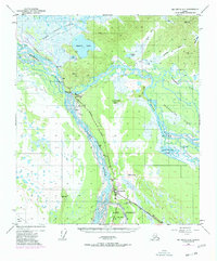
1950 Map of Big Delta A-4
USGS Topo · Published 1977About this map
The convergence of the Tanana River and the Delta River serves as the focal point for this interior Alaskan landscape, which highlights the critical transportation and military infrastructure of the mid-20th century. At the heart of the region sits Delta Junction, the historic terminus of the Alaska Highway where it meets the Richardson Highway. This strategic location is further emphasized by the presence of Fort Greely and Allen Airfield, alongside a decommissioned Military Pipeline and the later addition of The Trans-Alaska Pipeline.
Find a feature on this map
34 named features on this map. Tap any name to fly to it.
Don’t see what you’re looking for? This feature index may not catch every label — zoom into the map to look around manually.
Map Details
Editions of this 1950 Big Delta A-4 Map
4 editions found
Other maps of this area

1949 · Big Delta B-5
USGS Topo · 1:63,360

1950 · Mount Hayes
USGS Topo · 1:250,000

1950 · Big Delta
USGS Topo · 1:250,000

1950 · Big Delta A-5
USGS Topo · 1:63,360

1950 · Mount Hayes D-4
USGS Topo · 1:63,360

1950 · Big Delta A-4
USGS Topo · 1:63,360

1950 · Mount Hayes D-5
USGS Topo · 1:63,360

1950 · Big Delta B-4
USGS Topo · 1:63,360

1951 · Big Delta
USGS Topo · 1:250,000

1951 · Mount Hayes
USGS Topo · 1:250,000