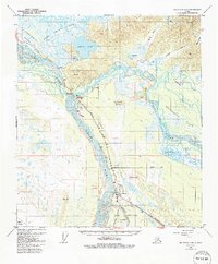
1950 Map of Big Delta A-4
USGS Topo · Published 1991About this map
Fort Greely and the strategic convergence of the Alaska Highway and Richardson Highway dominate this landscape during a period of significant infrastructure development. The map details the vital transportation corridors through the Interior, following the winding courses of the Tanana River and Delta River. This 1950s-era topography, updated with later revisions, shows the coexistence of military installations like Allen Airfield alongside remote outposts such as Jollys Cabins and Bluff Cabin.
Find a feature on this map
37 named features on this map. Tap any name to fly to it.
Don’t see what you’re looking for? This feature index may not catch every label — zoom into the map to look around manually.
Map Details
Editions of this 1950 Big Delta A-4 Map
4 editions found
Other maps of this area

1949 · Big Delta B-5
USGS Topo · 1:63,360

1950 · Mount Hayes
USGS Topo · 1:250,000

1950 · Big Delta
USGS Topo · 1:250,000

1950 · Big Delta A-5
USGS Topo · 1:63,360

1950 · Mount Hayes D-4
USGS Topo · 1:63,360

1950 · Big Delta A-4
USGS Topo · 1:63,360

1950 · Mount Hayes D-5
USGS Topo · 1:63,360

1950 · Big Delta B-4
USGS Topo · 1:63,360

1951 · Big Delta
USGS Topo · 1:250,000

1951 · Mount Hayes
USGS Topo · 1:250,000