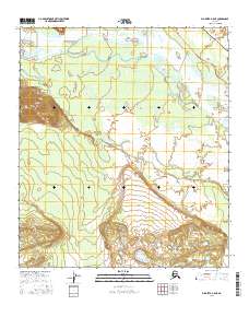
2016 Map of Big Delta A-5 NE
USGS Topo · Published 2016About this map
The Tanana River anchors the northern reaches of this Alaskan interior landscape, a region defined by its critical infrastructure and braided watercourses. In this 2016 survey, the modern industrial footprint is visible through the prominent path of the Alaska Pipeline, which traverses the terrain alongside the historic Richardson Highway. This alignment of the state's most vital transport and energy corridors illustrates the strategic importance of the corridor south of Big Delta. Beyond these man-made features, the map detail focuses on the wetlands and intricate drainage patterns of Clear Cr, showing the interaction between the heavy infrastructure of the north and the relatively undisturbed marshes and hills of the interior. The document serves as a high-resolution record of the mid-2010s landscape before any subsequent environmental or infrastructural shifts.
Find a feature on this map
8 named features on this map. Tap any name to fly to it.
Don’t see what you’re looking for? This feature index may not catch every label — zoom into the map to look around manually.
Map Details
Editions of this 2016 Big Delta A-5 NE Map
This is the sole edition of this map. No revisions or reprints were ever made.
Other maps of this area

1949 · Big Delta B-5
USGS Topo · 1:63,360

1950 · Big Delta
USGS Topo · 1:250,000

1950 · Big Delta A-5
USGS Topo · 1:63,360

1950 · Big Delta A-4
USGS Topo · 1:63,360

1950 · Big Delta B-4
USGS Topo · 1:63,360

1951 · Big Delta
USGS Topo · 1:250,000

1952 · Big Delta A-5
USGS Topo · 1:63,360

1952 · Big Delta A-4
USGS Topo · 1:63,360

1952 · Big Delta B-5
USGS Topo · 1:63,360

1953 · Big Delta B-4
USGS Topo · 1:63,360