
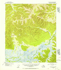
1953 Map of Big Delta B-4
USGS Topo · Published 1954About this map
Shaw Creek Flats dominates the southern landscape of this interior Alaska region, marking a significant topographical transition from the high ridges to the marshy lowlands of the Tanana River valley. Surveyed in the early 1950s using aerial photography, the map reveals an intricate drainage network where numerous tributaries like Cottonwood Creek and Rapid Creek flow into the larger Shaw Creek system. The northern half is defined by several high-elevation survey markers, including VABM 4084 Mid and VABM 3372 Cotton, which anchor the ridge lines between the deep valleys of Gilles Creek and Caribou Creek. This document captures the wilderness state of the Fourth Judicial Division before significant modern development, emphasizing the natural hydrology and the early geodetic control points used to chart the Alaskan interior.
Find a feature on this map
15 named features on this map. Tap any name to fly to it.
Don’t see what you’re looking for? This feature index may not catch every label — zoom into the map to look around manually.
Map Details
Editions of this 1953 Big Delta B-4 Map
2 editions found
Other maps of this area

1949 · Big Delta B-5
USGS Topo · 1:63,360

1950 · Big Delta
USGS Topo · 1:250,000

1950 · Big Delta A-5
USGS Topo · 1:63,360

1950 · Big Delta A-4
USGS Topo · 1:63,360

1950 · Big Delta B-4
USGS Topo · 1:63,360

1951 · Big Delta
USGS Topo · 1:250,000

1952 · Big Delta A-5
USGS Topo · 1:63,360

1952 · Big Delta A-4
USGS Topo · 1:63,360

1952 · Big Delta B-5
USGS Topo · 1:63,360

1955 · Big Delta A-3
USGS Topo · 1:63,360