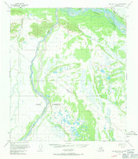
1950 Map of Big Delta A-5
USGS Topo · Published 1971About this map
The Tanana River sweeps across the northern reaches of this interior Alaska landscape, defining a complex network of braided channels and marshes in the mid-20th century. To the south, the massive expanse of the Fort Greely military reservation dominates the territory, its boundaries encompassing the southward-flowing Delta Creek. The map documents the region just as the postwar infrastructure was solidifying, showing the Richardson Highway tracing the northeastern corner as it parallels the river. Evidence of local habitation and seasonal use is sparse but specific, with labels for a lone Cabin and a cluster of Cabins located near the headwaters of Clear Creek. This survey provides a precise record of the land lines predetermined by the Bureau of Land Management for unsurveyed territory, illustrating the systematic effort to organize this portion of the Alaska interior during a period of expanding federal administration and strategic military presence.
Find a feature on this map
11 named features on this map. Tap any name to fly to it.
Don’t see what you’re looking for? This feature index may not catch every label — zoom into the map to look around manually.
Map Details
Editions of this 1950 Big Delta A-5 Map
4 editions found
Other maps of this area

1949 · Big Delta B-5
USGS Topo · 1:63,360

1949 · Big Delta B-6
USGS Topo · 1:63,360

1949 · Big Delta A-6
USGS Topo · 1:63,360

1950 · Mount Hayes
USGS Topo · 1:250,000

1950 · Big Delta
USGS Topo · 1:250,000

1950 · Big Delta A-5
USGS Topo · 1:63,360

1950 · Mount Hayes D-4
USGS Topo · 1:63,360

1950 · Big Delta A-4
USGS Topo · 1:63,360

1950 · Mount Hayes D-6
USGS Topo · 1:63,360

1950 · Mount Hayes D-5
USGS Topo · 1:63,360