
1949 Map of Big Delta A-6
USGS Topo · Published 1964About this map
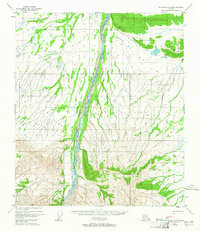
The Little Delta River dominates this interior Alaskan landscape, shown here as a complex braided waterway flowing through a corridor of low-lying marsh and swamp. These wetlands, interpreted from 1949 aerial photography, flank the river's path as it cuts through the Tanana Valley’s southern reaches. High-altitude triangulation stations like VABM Hayes 3641 and VABM Delta 1524 anchor the topography, reflecting the mid-century effort by the Geological Survey to map the territory's remote interior. The presence of a Winter Trail running north-south through the western terrain illustrates the seasonal nature of transportation in this region, where frozen ground once provided the primary route for travel across the otherwise impassable muskeg and river flats.
Find a feature on this map
4 named features on this map. Tap any name to fly to it.
Don’t see what you’re looking for? This feature index may not catch every label — zoom into the map to look around manually.
Map Details
Editions of this 1949 Big Delta A-6 Map
2 editions found
Other maps of this area

1949 · Big Delta B-5
USGS Topo · 1:63,360

1949 · Big Delta B-6
USGS Topo · 1:63,360

1949 · Fairbanks A-1
USGS Topo · 1:63,360

1949 · Healy D-1
USGS Topo · 1:63,360

1950 · Fairbanks
USGS Topo · 1:250,000

1950 · Mount Hayes
USGS Topo · 1:250,000

1950 · Big Delta
USGS Topo · 1:250,000

1950 · Big Delta A-5
USGS Topo · 1:63,360

1950 · Mount Hayes D-6
USGS Topo · 1:63,360

1950 · Mount Hayes D-5
USGS Topo · 1:63,360