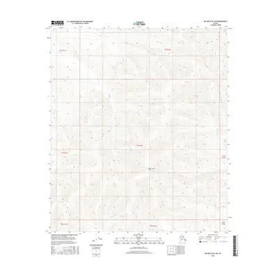
2016 Map of Big Delta B-3 SW
USGS Topo · Published 2016About this map
Shaw Creek Dome rises as a central topographic landmark in this interior Alaskan landscape, which is characterized by a dense network of watercourses and elevation contours. The drainage pattern is defined by Corda Cr in the west and Sand Cr and Eagle Cr to the east, illustrating the complex watershed of the Unorganized Borough. This 2016 survey, produced by the U.S. Geological Survey, meticulously documents the township and range boundaries including t7s r12e and t6s r12e. The absence of roads or permanent settlements in this quadrangle highlights its character as an undisturbed wilderness area, where the primary named features are the peaks and the creeks that carve through them.
Find a feature on this map
12 named features on this map. Tap any name to fly to it.
Don’t see what you’re looking for? This feature index may not catch every label — zoom into the map to look around manually.
Map Details
Editions of this 2016 Big Delta B-3 SW Map
This is the sole edition of this map. No revisions or reprints were ever made.
Other maps of this area

1950 · Big Delta
USGS Topo · 1:250,000

1950 · Big Delta A-4
USGS Topo · 1:63,360

1950 · Big Delta B-4
USGS Topo · 1:63,360

1951 · Big Delta
USGS Topo · 1:250,000

1952 · Big Delta A-4
USGS Topo · 1:63,360

1953 · Big Delta B-4
USGS Topo · 1:63,360

1955 · Big Delta A-3
USGS Topo · 1:63,360

1958 · Big Delta B-3
USGS Topo · 1:63,360

1958 · Big Delta
USGS Topo · 1:250,000
1959 · Big Delta A-4
USGS Topo · 1:63,360