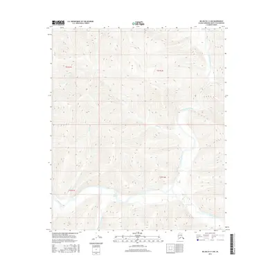
2016 Map of Big Delta C-3 NW
USGS Topo · Published 2016About this map
The Salcha River system dominates this Alaskan landscape in the Fairbanks North Star Borough, where the waterway transitions through a braided section known as The Splits. This area is defined by the convergence of major tributaries, including the South Fork Salcha River and the North Fork Salcha River, which flow through high-relief interior terrain. The drainage patterns are intricate, with smaller feeders like Mascot Cr, Bear Cr, and Goose Cr carving through the surrounding uplands. Higher elevations to the north and east are marked by Big Granite Cr and Little Granite Cr. This 2016 survey illustrates a largely uninhabited wilderness, documenting the precise natural topography and hydrography of the Tanana Valley watershed before its waters join the Tanana River downstream.
Find a feature on this map
14 named features on this map. Tap any name to fly to it.
Don’t see what you’re looking for? This feature index may not catch every label — zoom into the map to look around manually.
Map Details
Editions of this 2016 Big Delta C-3 NW Map
This is the sole edition of this map. No revisions or reprints were ever made.
Other maps of this area

1950 · Big Delta
USGS Topo · 1:250,000

1951 · Big Delta
USGS Topo · 1:250,000

1958 · Big Delta C-4
USGS Topo · 1:63,360

1958 · Big Delta D-4
USGS Topo · 1:63,360

1958 · Big Delta C-3
USGS Topo · 1:63,360

1958 · Big Delta D-3
USGS Topo · 1:63,360

1958 · Big Delta
USGS Topo · 1:250,000
1973 · Big Delta D-3
USGS Topo · 1:63,360
2016 · Big Delta D-4 SE
USGS Topo · 1:25,000
2016 · Big Delta C-3 SE
USGS Topo · 1:25,000