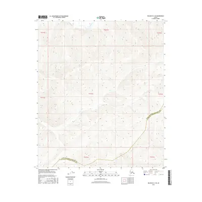
2016 Map of Big Delta C-3 SE
USGS Topo · Published 2016About this map
The Salcha River cuts across the northern edge of this interior landscape, marking a remote boundary line in the Alaskan wilderness. This 2016 survey highlights the stark divide where the Fairbanks North Star Borough meets the Southeast Fairbanks Census Area. The terrain is defined by high-elevation drainage systems, most notably the winding course of Camp Cr, which traverses the central and southern sections of the map. Unlike more developed regions, this area is characterized by its lack of established roads or settlements, shown here in its natural state through dense contour intervals and the Public Land Survey System grids of t3s r13e, t4s r13e, and surrounding townships. For those tracking land boundaries or natural watercourses, the map provides a precise look at the headwaters and tributaries that feed the regional river systems.
Find a feature on this map
11 named features on this map. Tap any name to fly to it.
Don’t see what you’re looking for? This feature index may not catch every label — zoom into the map to look around manually.
Map Details
Editions of this 2016 Big Delta C-3 SE Map
This is the sole edition of this map. No revisions or reprints were ever made.
Other maps of this area

1950 · Big Delta
USGS Topo · 1:250,000

1951 · Big Delta
USGS Topo · 1:250,000

1958 · Big Delta B-3
USGS Topo · 1:63,360

1958 · Big Delta C-3
USGS Topo · 1:63,360

1958 · Big Delta B-2
USGS Topo · 1:63,360

1958 · Big Delta C-2
USGS Topo · 1:63,360

1958 · Big Delta
USGS Topo · 1:250,000
2016 · Big Delta C-3 NW
USGS Topo · 1:25,000
2016 · Big Delta B-3 NE
USGS Topo · 1:25,000
2016 · Big Delta B-3 NW
USGS Topo · 1:25,000