
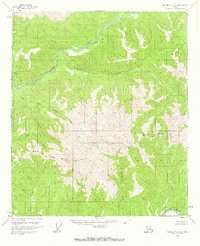
1958 Map of Big Delta C-2
USGS Topo · Published 1965About this map
Salcha River drainage dominates this interior Alaskan landscape, showing a region largely untouched by formal development in the late 1950s. The map illustrates a complex network of waterways including Porcupine Creek, Maiden Creek, and the dual branches of Upper Boulder Creek and Lower Boulder Creek. A single Cabin label on the western edge of the sheet provides the only evidence of human settlement, suggesting a lonely outpost for trapping or prospecting. The southern portion of the quadrangle is defined by the Goodpaster River and the high-elevation terrain surrounding Glacier Creek. This survey represents a period when the North Star Borough Boundary was a significant administrative marker across unsurveyed and unmarked land lines, as noted by the Bureau of Land Management. The topography, derived from early 1950s aerial photography, captures the drainage patterns before any modern road infrastructure entered this part of the Fairbanks region.
Find a feature on this map
11 named features on this map. Tap any name to fly to it.
Don’t see what you’re looking for? This feature index may not catch every label — zoom into the map to look around manually.
Map Details
Editions of this 1958 Big Delta C-2 Map
2 editions found
Other maps of this area

1950 · Big Delta
USGS Topo · 1:250,000

1951 · Big Delta
USGS Topo · 1:250,000

1958 · Big Delta B-3
USGS Topo · 1:63,360

1958 · Big Delta C-3
USGS Topo · 1:63,360

1958 · Big Delta D-3
USGS Topo · 1:63,360

1958 · Big Delta B-2
USGS Topo · 1:63,360

1958 · Big Delta B-1
USGS Topo · 1:63,360

1958 · Big Delta D-2
USGS Topo · 1:63,360

1958 · Big Delta D-1
USGS Topo · 1:63,360

1958 · Big Delta C-1
USGS Topo · 1:63,360