1958 Map of Big Delta C-1
USGS Topo · Published 1965About this map
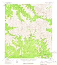
Goodpaster River and its numerous tributaries dominate this mid-century survey of the Alaskan interior. Based on aerial photography from 1954 and 1955, the map captures a landscape defined by its intricate drainage patterns rather than human infrastructure. The northern reaches of the sheet are marked by the Stone Boy Creek and the headwaters of the Charley River, while the southern portion tracks the winding path of Rock Creek and Slate Creek. The North Star Borough Boundary cuts through the northeast, indicating the early administrative divisions of the territory as it transitioned toward statehood. This document is particularly valuable for its recording of specific hydrologic features like Paldo Creek and Porcupine Creek before later developments or name changes occurred in this part of Southeast Fairbanks.
Find a feature on this map
8 named features on this map. Tap any name to fly to it.
Don’t see what you’re looking for? This feature index may not catch every label — zoom into the map to look around manually.
Map Details
Editions of this 1958 Big Delta C-1 Map
2 editions found
Historical Maps of Unorganized Borough Through Time
634 maps found

1899 Fortymile
Southeast Fairbanks Borough, AK

1948 Tanacross A-3
Southeast Fairbanks Borough, AK

1948 Tanacross A-4
Southeast Fairbanks Borough, AK

1948 Tanacross A-5
Southeast Fairbanks Borough, AK

1948 Tanacross A-6
Southeast Fairbanks Borough, AK

1948 Tanacross B-3
Southeast Fairbanks Borough, AK

1948 Tanacross B-5
Southeast Fairbanks Borough, AK

1949 Big Delta A-6
Southeast Fairbanks Borough, AK

1949 Tanacross A-5
Southeast Fairbanks Borough, AK

1949 Tanacross B-3
Southeast Fairbanks Borough, AK

1949 Tanacross B-4
Southeast Fairbanks Borough, AK

1949 Tanacross B-6
Southeast Fairbanks Borough, AK

1950 Big Delta A-4
Southeast Fairbanks Borough, AK

1950 Big Delta A-5
Southeast Fairbanks Borough, AK

1950 Big Delta B-4
Southeast Fairbanks Borough, AK

1950 Mount Hayes D-5
Southeast Fairbanks Borough, AK

1950 Mount Hayes D-6
Southeast Fairbanks Borough, AK

1950 Mount Hayes
Southeast Fairbanks Borough, AK

1950 Mt. Hayes C-4
Southeast Fairbanks Borough, AK

1950 Mt. Hayes D-1
Southeast Fairbanks Borough, AK

1951 Big Delta A-6
Southeast Fairbanks Borough, AK

1951 Mount Hayes C-5
Southeast Fairbanks Borough, AK

1951 Mount Hayes C-6
Southeast Fairbanks Borough, AK

1951 Mount Hayes
Southeast Fairbanks Borough, AK

1951 Tanacross B-4
Southeast Fairbanks Borough, AK

1951 Tanacross B-6
Southeast Fairbanks Borough, AK

1952 Big Delta A-4
Southeast Fairbanks Borough, AK

1952 Big Delta A-5
Southeast Fairbanks Borough, AK

1952 Mt. Hayes C-4
Southeast Fairbanks Borough, AK

1952 Mt. Hayes D-4
Southeast Fairbanks Borough, AK

1952 Mt. Hayes D-5
Southeast Fairbanks Borough, AK

1952 Mt. Hayes D-6
Southeast Fairbanks Borough, AK

1952 Nabesna D-1
Southeast Fairbanks Borough, AK

1952 Tanacross A-1
Southeast Fairbanks Borough, AK

1952 Tanacross A-3
Southeast Fairbanks Borough, AK

1952 Tanacross A-4
Southeast Fairbanks Borough, AK

1952 Tanacross A-5
Southeast Fairbanks Borough, AK

1952 Tanacross A-6
Southeast Fairbanks Borough, AK

1952 Tanacross B-3
Southeast Fairbanks Borough, AK

1952 Tanacross B-5
Southeast Fairbanks Borough, AK

1953 Big Delta B-4
Southeast Fairbanks Borough, AK

1954 Big Delta A-2
Southeast Fairbanks Borough, AK

1954 Mount Hayes C-1
Southeast Fairbanks Borough, AK

1954 Mount Hayes C-3
Southeast Fairbanks Borough, AK

1954 Mount Hayes D-2
Southeast Fairbanks Borough, AK

1954 Mount Hayes D-3
Southeast Fairbanks Borough, AK

1954 Mt. Hayes D-1
Southeast Fairbanks Borough, AK

1954 Nabesna C-3
Southeast Fairbanks Borough, AK

1954 Nabesna D-2
Southeast Fairbanks Borough, AK

1954 Nabesna D-3
Southeast Fairbanks Borough, AK

1954 Nabesna D-4
Southeast Fairbanks Borough, AK

1954 Tanacross A-2
Southeast Fairbanks Borough, AK

1954 Tanacross C-6
Southeast Fairbanks Borough, AK

1954 Tanacross D-6
Southeast Fairbanks Borough, AK

1955 Big Delta A-1
Southeast Fairbanks Borough, AK

1955 Big Delta A-2
Southeast Fairbanks Borough, AK

1955 Big Delta A-3
Southeast Fairbanks Borough, AK

1955 Mount Hayes C-1
Southeast Fairbanks Borough, AK

1955 Mount Hayes C-2
Southeast Fairbanks Borough, AK

1955 Mount Hayes C-3
Southeast Fairbanks Borough, AK

1955 Mount Hayes D-2
Southeast Fairbanks Borough, AK

1955 Mount Hayes
Southeast Fairbanks Borough, AK

1955 Mt. Hayes D-3
Southeast Fairbanks Borough, AK

1955 Nabesna C-1
Southeast Fairbanks Borough, AK

1955 Nabesna C-2
Southeast Fairbanks Borough, AK

1955 Nabesna C-3
Southeast Fairbanks Borough, AK

1955 Nabesna D-2
Southeast Fairbanks Borough, AK

1955 Nabesna D-3
Southeast Fairbanks Borough, AK

1955 Tanacross A-2
Southeast Fairbanks Borough, AK

1955 Tanacross C-6
Southeast Fairbanks Borough, AK

1955 Tanacross D-6
Southeast Fairbanks Borough, AK

1956 Charley River A-1
Southeast Fairbanks Borough, AK

1956 Charley River A-2
Southeast Fairbanks Borough, AK

1956 Charley River A-3
Southeast Fairbanks Borough, AK

1956 Charley River A-4
Southeast Fairbanks Borough, AK

1956 Charley River B-1
Southeast Fairbanks Borough, AK

1956 Charley River B-2
Southeast Fairbanks Borough, AK

1956 Charley River B-3
Southeast Fairbanks Borough, AK

1956 Charley River C-1
Southeast Fairbanks Borough, AK

1956 Eagle A-1
Southeast Fairbanks Borough, AK

1956 Eagle A-2
Southeast Fairbanks Borough, AK

1956 Eagle A-4
Southeast Fairbanks Borough, AK

1956 Eagle A-5
Southeast Fairbanks Borough, AK

1956 Eagle A-6
Southeast Fairbanks Borough, AK

1956 Eagle B-1
Southeast Fairbanks Borough, AK

1956 Eagle B-2
Southeast Fairbanks Borough, AK

1956 Eagle B-3
Southeast Fairbanks Borough, AK

1956 Eagle B-4
Southeast Fairbanks Borough, AK

1956 Eagle B-5
Southeast Fairbanks Borough, AK

1956 Eagle B-6
Southeast Fairbanks Borough, AK

1956 Eagle C-1
Southeast Fairbanks Borough, AK

1956 Eagle C-2
Southeast Fairbanks Borough, AK

1956 Eagle C-3
Southeast Fairbanks Borough, AK

1956 Eagle C-4
Southeast Fairbanks Borough, AK

1956 Eagle C-5
Southeast Fairbanks Borough, AK

1956 Eagle C-6
Southeast Fairbanks Borough, AK

1956 Eagle D-1
Southeast Fairbanks Borough, AK

1956 Eagle D-2
Southeast Fairbanks Borough, AK

1956 Eagle D-3
Southeast Fairbanks Borough, AK

1956 Eagle D-4
Southeast Fairbanks Borough, AK

1956 Eagle D-5
Southeast Fairbanks Borough, AK

1956 Tanacross B-1
Southeast Fairbanks Borough, AK

1956 Tanacross B-2
Southeast Fairbanks Borough, AK

1956 Tanacross C-1
Southeast Fairbanks Borough, AK

1956 Tanacross C-2
Southeast Fairbanks Borough, AK

1956 Tanacross C-3
Southeast Fairbanks Borough, AK

1956 Tanacross C-4
Southeast Fairbanks Borough, AK

1956 Tanacross C-5
Southeast Fairbanks Borough, AK

1956 Tanacross D-1
Southeast Fairbanks Borough, AK

1956 Tanacross D-2
Southeast Fairbanks Borough, AK

1956 Tanacross D-3
Southeast Fairbanks Borough, AK

1956 Tanacross D-4
Southeast Fairbanks Borough, AK

1956 Tanacross D-5
Southeast Fairbanks Borough, AK

1957 Eagle A-3
Southeast Fairbanks Borough, AK

1958 Big Delta B-1
Southeast Fairbanks Borough, AK

1958 Big Delta B-2
Southeast Fairbanks Borough, AK

1958 Big Delta B-3
Southeast Fairbanks Borough, AK

1958 Big Delta C-1
Southeast Fairbanks Borough, AK

1959 Big Delta A-4
Southeast Fairbanks Borough, AK

1959 Nabesna A-1
Southeast Fairbanks Borough, AK

1960 Nabesna A-2
Southeast Fairbanks Borough, AK

1960 Nabesna B-1
Southeast Fairbanks Borough, AK

1960 Nabesna B-2
Southeast Fairbanks Borough, AK

1960 Nabesna D-4
Southeast Fairbanks Borough, AK

1962 Big Delta A-4
Southeast Fairbanks Borough, AK

2013 Big Delta A-5 SE
Southeast Fairbanks Borough, AK

2013 Big Delta A-5 SW
Southeast Fairbanks Borough, AK

2013 Mount Hayes D-1 NE
Southeast Fairbanks Borough, AK

2013 Mount Hayes D-5 NE
Southeast Fairbanks Borough, AK

2013 Mount Hayes D-5 NW
Southeast Fairbanks Borough, AK

2013 Nabesna C-1 NE
Southeast Fairbanks Borough, AK

2013 Nabesna D-1 NE
Southeast Fairbanks Borough, AK

2013 Nabesna D-1 SE
Southeast Fairbanks Borough, AK

2013 Tanacross A-1 NE
Southeast Fairbanks Borough, AK

2013 Tanacross A-1 NW
Southeast Fairbanks Borough, AK

2013 Tanacross A-1 SE
Southeast Fairbanks Borough, AK

2013 Tanacross A-1 SW
Southeast Fairbanks Borough, AK

2013 Tanacross A-2 NE
Southeast Fairbanks Borough, AK

2013 Tanacross A-2 NW
Southeast Fairbanks Borough, AK

2013 Tanacross A-2 SE
Southeast Fairbanks Borough, AK

2013 Tanacross A-2 SW
Southeast Fairbanks Borough, AK

2013 Tanacross A-3 NE
Southeast Fairbanks Borough, AK

2013 Tanacross A-3 SE
Southeast Fairbanks Borough, AK

2013 Tanacross B-2 NW
Southeast Fairbanks Borough, AK

2013 Tanacross B-2 SW
Southeast Fairbanks Borough, AK

2013 Tanacross B-3 NE
Southeast Fairbanks Borough, AK

2013 Tanacross B-3 SE
Southeast Fairbanks Borough, AK

2013 Tanacross C-2 NE
Southeast Fairbanks Borough, AK

2013 Tanacross C-2 NW
Southeast Fairbanks Borough, AK

2013 Tanacross C-2 SE
Southeast Fairbanks Borough, AK

2013 Tanacross C-2 SW
Southeast Fairbanks Borough, AK

2013 Tanacross C-3 NE
Southeast Fairbanks Borough, AK

2013 Tanacross C-3 NW
Southeast Fairbanks Borough, AK

2013 Tanacross C-3 SE
Southeast Fairbanks Borough, AK

2013 Tanacross C-3 SW
Southeast Fairbanks Borough, AK

2013 Tanacross C-4 NE
Southeast Fairbanks Borough, AK

2013 Tanacross C-4 NW
Southeast Fairbanks Borough, AK

2013 Tanacross C-4 SE
Southeast Fairbanks Borough, AK

2013 Tanacross C-4 SW
Southeast Fairbanks Borough, AK

2013 Tanacross C-5 NE
Southeast Fairbanks Borough, AK

2013 Tanacross C-5 SE
Southeast Fairbanks Borough, AK

2013 Tanacross D-1 NE
Southeast Fairbanks Borough, AK

2013 Tanacross D-1 NW
Southeast Fairbanks Borough, AK

2013 Tanacross D-2 NE
Southeast Fairbanks Borough, AK

2013 Tanacross D-2 NW
Southeast Fairbanks Borough, AK

2013 Tanacross D-2 SE
Southeast Fairbanks Borough, AK

2013 Tanacross D-2 SW
Southeast Fairbanks Borough, AK

2013 Tanacross D-3 NE
Southeast Fairbanks Borough, AK

2013 Tanacross D-3 NW
Southeast Fairbanks Borough, AK

2013 Tanacross D-3 SE
Southeast Fairbanks Borough, AK

2013 Tanacross D-3 SW
Southeast Fairbanks Borough, AK

2013 Tanacross D-4 NE
Southeast Fairbanks Borough, AK

2013 Tanacross D-4 NW
Southeast Fairbanks Borough, AK

2013 Tanacross D-4 SE
Southeast Fairbanks Borough, AK

2013 Tanacross D-4 SW
Southeast Fairbanks Borough, AK

2013 Tanacross D-5 NE
Southeast Fairbanks Borough, AK

2013 Tanacross D-5 NW
Southeast Fairbanks Borough, AK

2013 Tanacross D-5 SE
Southeast Fairbanks Borough, AK

2013 Tanacross D-6 NE
Southeast Fairbanks Borough, AK

2013 Tanacross D-6 NW
Southeast Fairbanks Borough, AK

2015 Tanacross B-1 NE
Southeast Fairbanks Borough, AK

2015 Tanacross B-1 NW
Southeast Fairbanks Borough, AK

2015 Tanacross B-1 SE
Southeast Fairbanks Borough, AK

2015 Tanacross B-1 SW
Southeast Fairbanks Borough, AK

2015 Tanacross B-2 NE
Southeast Fairbanks Borough, AK

2015 Tanacross B-2 SE
Southeast Fairbanks Borough, AK

2015 Tanacross C-1 NE
Southeast Fairbanks Borough, AK

2015 Tanacross C-1 NW
Southeast Fairbanks Borough, AK

2015 Tanacross C-1 SE
Southeast Fairbanks Borough, AK

2015 Tanacross C-1 SW
Southeast Fairbanks Borough, AK

2015 Tanacross D-1 SE
Southeast Fairbanks Borough, AK

2015 Tanacross D-1 SW
Southeast Fairbanks Borough, AK

2016 Big Delta A-3 NE
Southeast Fairbanks Borough, AK

2016 Big Delta A-3 NW
Southeast Fairbanks Borough, AK

2016 Big Delta A-3 SE
Southeast Fairbanks Borough, AK

2016 Big Delta A-3 SW
Southeast Fairbanks Borough, AK

2016 Big Delta A-4 NE
Southeast Fairbanks Borough, AK

2016 Big Delta A-4 NW
Southeast Fairbanks Borough, AK

2016 Big Delta A-4 SE
Southeast Fairbanks Borough, AK

2016 Big Delta A-4 SW
Southeast Fairbanks Borough, AK

2016 Big Delta A-5 NE
Southeast Fairbanks Borough, AK

2016 Big Delta A-5 NW
Southeast Fairbanks Borough, AK

2016 Big Delta A-6 NE
Southeast Fairbanks Borough, AK

2016 Big Delta A-6 NW
Southeast Fairbanks Borough, AK

2016 Big Delta A-6 SE
Southeast Fairbanks Borough, AK

2016 Big Delta A-6 SW
Southeast Fairbanks Borough, AK

2016 Big Delta B-3 NE
Southeast Fairbanks Borough, AK

2016 Big Delta B-3 NW
Southeast Fairbanks Borough, AK

2016 Big Delta B-3 SE
Southeast Fairbanks Borough, AK

2016 Big Delta B-3 SW
Southeast Fairbanks Borough, AK

2016 Big Delta B-4 NE
Southeast Fairbanks Borough, AK

2016 Big Delta B-4 NW
Southeast Fairbanks Borough, AK

2016 Big Delta B-4 SE
Southeast Fairbanks Borough, AK

2016 Big Delta B-4 SW
Southeast Fairbanks Borough, AK

2016 Big Delta B-5 SE
Southeast Fairbanks Borough, AK

2016 Mount Hayes C-1 NE
Southeast Fairbanks Borough, AK

2016 Mount Hayes C-1 NW
Southeast Fairbanks Borough, AK

2016 Mount Hayes C-1 SE
Southeast Fairbanks Borough, AK

2016 Mount Hayes C-1 SW
Southeast Fairbanks Borough, AK

2016 Mount Hayes C-2 NE
Southeast Fairbanks Borough, AK

2016 Mount Hayes C-2 NW
Southeast Fairbanks Borough, AK

2016 Mount Hayes C-2 SE
Southeast Fairbanks Borough, AK

2016 Mount Hayes C-2 SW
Southeast Fairbanks Borough, AK

2016 Mount Hayes C-3 NE
Southeast Fairbanks Borough, AK

2016 Mount Hayes C-3 NW
Southeast Fairbanks Borough, AK

2016 Mount Hayes C-3 SE
Southeast Fairbanks Borough, AK

2016 Mount Hayes C-3 SW
Southeast Fairbanks Borough, AK

2016 Mount Hayes C-4 NE
Southeast Fairbanks Borough, AK

2016 Mount Hayes C-4 NW
Southeast Fairbanks Borough, AK

2016 Mount Hayes C-4 SE
Southeast Fairbanks Borough, AK

2016 Mount Hayes C-4 SW
Southeast Fairbanks Borough, AK

2016 Mount Hayes C-5 NE
Southeast Fairbanks Borough, AK

2016 Mount Hayes C-5 NW
Southeast Fairbanks Borough, AK

2016 Mount Hayes C-5 SE
Southeast Fairbanks Borough, AK

2016 Mount Hayes C-5 SW
Southeast Fairbanks Borough, AK

2016 Mount Hayes C-6 NE
Southeast Fairbanks Borough, AK

2016 Mount Hayes C-6 NW
Southeast Fairbanks Borough, AK

2016 Mount Hayes D-1 NW
Southeast Fairbanks Borough, AK

2016 Mount Hayes D-1 SE
Southeast Fairbanks Borough, AK

2016 Mount Hayes D-1 SW
Southeast Fairbanks Borough, AK

2016 Mount Hayes D-2 NE
Southeast Fairbanks Borough, AK

2016 Mount Hayes D-2 NW
Southeast Fairbanks Borough, AK

2016 Mount Hayes D-2 SE
Southeast Fairbanks Borough, AK

2016 Mount Hayes D-2 SW
Southeast Fairbanks Borough, AK

2016 Mount Hayes D-3 NE
Southeast Fairbanks Borough, AK

2016 Mount Hayes D-3 NW
Southeast Fairbanks Borough, AK

2016 Mount Hayes D-3 SE
Southeast Fairbanks Borough, AK

2016 Mount Hayes D-3 SW
Southeast Fairbanks Borough, AK

2016 Mount Hayes D-4 NE
Southeast Fairbanks Borough, AK

2016 Mount Hayes D-4 NW
Southeast Fairbanks Borough, AK

2016 Mount Hayes D-4 SE
Southeast Fairbanks Borough, AK

2016 Mount Hayes D-4 SW
Southeast Fairbanks Borough, AK

2016 Mount Hayes D-5 SE
Southeast Fairbanks Borough, AK

2016 Mount Hayes D-5 SW
Southeast Fairbanks Borough, AK

2016 Mount Hayes D-6 NE
Southeast Fairbanks Borough, AK

2016 Mount Hayes D-6 NW
Southeast Fairbanks Borough, AK

2016 Mount Hayes D-6 SE
Southeast Fairbanks Borough, AK

2016 Mount Hayes D-6 SW
Southeast Fairbanks Borough, AK

2016 Nabesna A-1 NE
Southeast Fairbanks Borough, AK

2016 Nabesna A-1 NW
Southeast Fairbanks Borough, AK

2016 Nabesna A-1 SE
Southeast Fairbanks Borough, AK

2016 Nabesna A-1 SW
Southeast Fairbanks Borough, AK

2016 Nabesna A-2 NE
Southeast Fairbanks Borough, AK

2016 Nabesna A-2 NW
Southeast Fairbanks Borough, AK

2016 Nabesna A-2 SE
Southeast Fairbanks Borough, AK

2016 Nabesna B-1 NE
Southeast Fairbanks Borough, AK

2016 Nabesna B-1 NW
Southeast Fairbanks Borough, AK

2016 Nabesna B-1 SE
Southeast Fairbanks Borough, AK

2016 Nabesna B-1 SW
Southeast Fairbanks Borough, AK

2016 Nabesna B-2 NE
Southeast Fairbanks Borough, AK

2016 Nabesna B-2 NW
Southeast Fairbanks Borough, AK

2016 Nabesna B-2 SE
Southeast Fairbanks Borough, AK

2016 Nabesna B-2 SW
Southeast Fairbanks Borough, AK

2016 Nabesna C-1 NW
Southeast Fairbanks Borough, AK

2016 Nabesna C-1 SE
Southeast Fairbanks Borough, AK

2016 Nabesna C-1 SW
Southeast Fairbanks Borough, AK

2016 Nabesna C-2 NE
Southeast Fairbanks Borough, AK

2016 Nabesna C-2 NW
Southeast Fairbanks Borough, AK

2016 Nabesna C-2 SE
Southeast Fairbanks Borough, AK

2016 Nabesna C-2 SW
Southeast Fairbanks Borough, AK

2016 Nabesna C-3 NE
Southeast Fairbanks Borough, AK

2016 Nabesna C-3 NW
Southeast Fairbanks Borough, AK

2016 Nabesna C-3 SE
Southeast Fairbanks Borough, AK

2016 Nabesna C-4 NW
Southeast Fairbanks Borough, AK

2016 Nabesna D-1 SW
Southeast Fairbanks Borough, AK

2016 Nabesna D-2 NW
Southeast Fairbanks Borough, AK

2016 Nabesna D-2 SE
Southeast Fairbanks Borough, AK

2016 Nabesna D-2 SW
Southeast Fairbanks Borough, AK

2016 Nabesna D-3 NE
Southeast Fairbanks Borough, AK

2016 Nabesna D-3 NW
Southeast Fairbanks Borough, AK

2016 Nabesna D-3 SE
Southeast Fairbanks Borough, AK

2016 Nabesna D-3 SW
Southeast Fairbanks Borough, AK

2016 Nabesna D-4 NE
Southeast Fairbanks Borough, AK

2016 Nabesna D-4 NW
Southeast Fairbanks Borough, AK

2016 Nabesna D-4 SE
Southeast Fairbanks Borough, AK

2016 Nabesna D-4 SW
Southeast Fairbanks Borough, AK

2016 Tanacross A-3 NW
Southeast Fairbanks Borough, AK

2016 Tanacross A-3 SW
Southeast Fairbanks Borough, AK

2016 Tanacross A-4 NE
Southeast Fairbanks Borough, AK

2016 Tanacross A-4 NW
Southeast Fairbanks Borough, AK

2016 Tanacross A-4 SE
Southeast Fairbanks Borough, AK

2016 Tanacross A-4 SW
Southeast Fairbanks Borough, AK

2016 Tanacross A-5 NE
Southeast Fairbanks Borough, AK

2016 Tanacross A-5 NW
Southeast Fairbanks Borough, AK

2016 Tanacross A-6 NE
Southeast Fairbanks Borough, AK

2016 Tanacross A-6 NW
Southeast Fairbanks Borough, AK

2016 Tanacross B-3 NW
Southeast Fairbanks Borough, AK

2016 Tanacross B-3 SW
Southeast Fairbanks Borough, AK

2016 Tanacross B-4 NE
Southeast Fairbanks Borough, AK

2016 Tanacross B-4 NW
Southeast Fairbanks Borough, AK

2016 Tanacross B-4 SE
Southeast Fairbanks Borough, AK

2016 Tanacross B-4 SW
Southeast Fairbanks Borough, AK

2016 Tanacross B-5 NE
Southeast Fairbanks Borough, AK

2016 Tanacross B-5 NW
Southeast Fairbanks Borough, AK

2016 Tanacross B-5 SE
Southeast Fairbanks Borough, AK

2016 Tanacross B-5 SW
Southeast Fairbanks Borough, AK

2016 Tanacross B-6 NE
Southeast Fairbanks Borough, AK

2016 Tanacross B-6 NW
Southeast Fairbanks Borough, AK

2016 Tanacross B-6 SE
Southeast Fairbanks Borough, AK

2016 Tanacross B-6 SW
Southeast Fairbanks Borough, AK

2016 Tanacross C-5 NW
Southeast Fairbanks Borough, AK

2016 Tanacross C-5 SW
Southeast Fairbanks Borough, AK

2016 Tanacross C-6 NE
Southeast Fairbanks Borough, AK

2016 Tanacross C-6 NW
Southeast Fairbanks Borough, AK

2016 Tanacross C-6 SE
Southeast Fairbanks Borough, AK

2016 Tanacross C-6 SW
Southeast Fairbanks Borough, AK

2016 Tanacross D-5 SW
Southeast Fairbanks Borough, AK

2016 Tanacross D-6 SE
Southeast Fairbanks Borough, AK

2016 Tanacross D-6 SW
Southeast Fairbanks Borough, AK

2017 Nabesna D-1 NW
Southeast Fairbanks Borough, AK

2017 Nabesna D-2 NE
Southeast Fairbanks Borough, AK

2018 Big Delta A-1 NE
Southeast Fairbanks Borough, AK

2018 Big Delta A-1 NW
Southeast Fairbanks Borough, AK

2018 Big Delta A-1 SE
Southeast Fairbanks Borough, AK

2018 Big Delta A-1 SW
Southeast Fairbanks Borough, AK

2018 Big Delta A-2 NE
Southeast Fairbanks Borough, AK

2018 Big Delta A-2 NW
Southeast Fairbanks Borough, AK

2018 Big Delta A-2 SE
Southeast Fairbanks Borough, AK

2018 Big Delta A-2 SW
Southeast Fairbanks Borough, AK

2018 Big Delta B-1 NE
Southeast Fairbanks Borough, AK

2018 Big Delta B-1 NW
Southeast Fairbanks Borough, AK

2018 Big Delta B-1 SE
Southeast Fairbanks Borough, AK

2018 Big Delta B-1 SW
Southeast Fairbanks Borough, AK

2018 Big Delta B-2 NE
Southeast Fairbanks Borough, AK

2018 Big Delta B-2 NW
Southeast Fairbanks Borough, AK

2018 Big Delta B-2 SE
Southeast Fairbanks Borough, AK

2018 Big Delta B-2 SW
Southeast Fairbanks Borough, AK

2018 Big Delta C-1 SE
Southeast Fairbanks Borough, AK

2018 Big Delta C-1 SW
Southeast Fairbanks Borough, AK

2018 Big Delta C-2 SE
Southeast Fairbanks Borough, AK

2018 Big Delta C-2 SW
Southeast Fairbanks Borough, AK

2018 Charley River A-1 NE
Southeast Fairbanks Borough, AK

2018 Charley River A-1 NW
Southeast Fairbanks Borough, AK

2018 Charley River A-1 SE
Southeast Fairbanks Borough, AK

2018 Charley River A-1 SW
Southeast Fairbanks Borough, AK

2018 Charley River A-2 NE
Southeast Fairbanks Borough, AK

2018 Charley River A-2 NW
Southeast Fairbanks Borough, AK

2018 Charley River A-2 SE
Southeast Fairbanks Borough, AK

2018 Charley River A-2 SW
Southeast Fairbanks Borough, AK

2018 Charley River A-3 NE
Southeast Fairbanks Borough, AK

2018 Charley River A-3 NW
Southeast Fairbanks Borough, AK

2018 Charley River A-3 SE
Southeast Fairbanks Borough, AK

2018 Charley River A-3 SW
Southeast Fairbanks Borough, AK

2018 Charley River A-4 NE
Southeast Fairbanks Borough, AK

2018 Charley River A-4 SE
Southeast Fairbanks Borough, AK

2018 Charley River A-4 SW
Southeast Fairbanks Borough, AK

2018 Charley River A-5 SE
Southeast Fairbanks Borough, AK

2018 Charley River B-1 NE
Southeast Fairbanks Borough, AK

2018 Charley River B-1 NW
Southeast Fairbanks Borough, AK

2018 Charley River B-1 SE
Southeast Fairbanks Borough, AK

2018 Charley River B-1 SW
Southeast Fairbanks Borough, AK

2018 Charley River B-2 NE
Southeast Fairbanks Borough, AK

2018 Charley River B-2 NW
Southeast Fairbanks Borough, AK

2018 Charley River B-2 SE
Southeast Fairbanks Borough, AK

2018 Charley River B-2 SW
Southeast Fairbanks Borough, AK

2018 Charley River B-3 NE
Southeast Fairbanks Borough, AK

2018 Charley River B-3 SE
Southeast Fairbanks Borough, AK

2018 Charley River B-3 SW
Southeast Fairbanks Borough, AK

2018 Charley River B-4 SE
Southeast Fairbanks Borough, AK

2018 Charley River C-1 NE
Southeast Fairbanks Borough, AK

2018 Charley River C-1 SE
Southeast Fairbanks Borough, AK

2018 Charley River C-1 SW
Southeast Fairbanks Borough, AK

2018 Charley River D-1 SE
Southeast Fairbanks Borough, AK

2018 Eagle A-1 NE
Southeast Fairbanks Borough, AK

2018 Eagle A-1 NW
Southeast Fairbanks Borough, AK

2018 Eagle A-1 SE
Southeast Fairbanks Borough, AK

2018 Eagle A-1 SW
Southeast Fairbanks Borough, AK

2018 Eagle A-2 NE
Southeast Fairbanks Borough, AK

2018 Eagle A-2 NW
Southeast Fairbanks Borough, AK

2018 Eagle A-2 SE
Southeast Fairbanks Borough, AK

2018 Eagle A-2 SW
Southeast Fairbanks Borough, AK

2018 Eagle A-3 NE
Southeast Fairbanks Borough, AK

2018 Eagle A-3 NW
Southeast Fairbanks Borough, AK

2018 Eagle A-3 SE
Southeast Fairbanks Borough, AK

2018 Eagle A-3 SW
Southeast Fairbanks Borough, AK

2018 Eagle A-4 NE
Southeast Fairbanks Borough, AK

2018 Eagle A-4 NW
Southeast Fairbanks Borough, AK

2018 Eagle A-4 SE
Southeast Fairbanks Borough, AK

2018 Eagle A-4 SW
Southeast Fairbanks Borough, AK

2018 Eagle A-5 NE
Southeast Fairbanks Borough, AK

2018 Eagle A-5 NW
Southeast Fairbanks Borough, AK

2018 Eagle A-5 SE
Southeast Fairbanks Borough, AK

2018 Eagle A-5 SW
Southeast Fairbanks Borough, AK

2018 Eagle A-6 NE
Southeast Fairbanks Borough, AK

2018 Eagle A-6 NW
Southeast Fairbanks Borough, AK

2018 Eagle A-6 SE
Southeast Fairbanks Borough, AK

2018 Eagle A-6 SW
Southeast Fairbanks Borough, AK

2018 Eagle B-1 NE
Southeast Fairbanks Borough, AK

2018 Eagle B-1 NW
Southeast Fairbanks Borough, AK

2018 Eagle B-1 SE
Southeast Fairbanks Borough, AK

2018 Eagle B-1 SW
Southeast Fairbanks Borough, AK

2018 Eagle B-2 NE
Southeast Fairbanks Borough, AK

2018 Eagle B-2 NW
Southeast Fairbanks Borough, AK

2018 Eagle B-2 SE
Southeast Fairbanks Borough, AK

2018 Eagle B-2 SW
Southeast Fairbanks Borough, AK

2018 Eagle B-3 NE
Southeast Fairbanks Borough, AK

2018 Eagle B-3 NW
Southeast Fairbanks Borough, AK

2018 Eagle B-3 SE
Southeast Fairbanks Borough, AK

2018 Eagle B-3 SW
Southeast Fairbanks Borough, AK

2018 Eagle B-4 NE
Southeast Fairbanks Borough, AK

2018 Eagle B-4 NW
Southeast Fairbanks Borough, AK

2018 Eagle B-4 SE
Southeast Fairbanks Borough, AK

2018 Eagle B-4 SW
Southeast Fairbanks Borough, AK

2018 Eagle B-5 NE
Southeast Fairbanks Borough, AK

2018 Eagle B-5 NW
Southeast Fairbanks Borough, AK

2018 Eagle B-5 SE
Southeast Fairbanks Borough, AK

2018 Eagle B-5 SW
Southeast Fairbanks Borough, AK

2018 Eagle B-6 NE
Southeast Fairbanks Borough, AK

2018 Eagle B-6 NW
Southeast Fairbanks Borough, AK

2018 Eagle B-6 SE
Southeast Fairbanks Borough, AK

2018 Eagle B-6 SW
Southeast Fairbanks Borough, AK

2018 Eagle C-1 NE
Southeast Fairbanks Borough, AK

2018 Eagle C-1 NW
Southeast Fairbanks Borough, AK

2018 Eagle C-1 SE
Southeast Fairbanks Borough, AK

2018 Eagle C-1 SW
Southeast Fairbanks Borough, AK

2018 Eagle C-2 NE
Southeast Fairbanks Borough, AK

2018 Eagle C-2 NW
Southeast Fairbanks Borough, AK

2018 Eagle C-2 SE
Southeast Fairbanks Borough, AK

2018 Eagle C-2 SW
Southeast Fairbanks Borough, AK

2018 Eagle C-3 NE
Southeast Fairbanks Borough, AK

2018 Eagle C-3 NW
Southeast Fairbanks Borough, AK

2018 Eagle C-3 SE
Southeast Fairbanks Borough, AK

2018 Eagle C-3 SW
Southeast Fairbanks Borough, AK

2018 Eagle C-4 NE
Southeast Fairbanks Borough, AK

2018 Eagle C-4 NW
Southeast Fairbanks Borough, AK

2018 Eagle C-4 SE
Southeast Fairbanks Borough, AK

2018 Eagle C-4 SW
Southeast Fairbanks Borough, AK

2018 Eagle C-5 NE
Southeast Fairbanks Borough, AK

2018 Eagle C-5 NW
Southeast Fairbanks Borough, AK

2018 Eagle C-5 SE
Southeast Fairbanks Borough, AK

2018 Eagle C-5 SW
Southeast Fairbanks Borough, AK

2018 Eagle C-6 NE
Southeast Fairbanks Borough, AK

2018 Eagle C-6 SE
Southeast Fairbanks Borough, AK

2018 Eagle C-6 SW
Southeast Fairbanks Borough, AK

2018 Eagle D-1 NE
Southeast Fairbanks Borough, AK

2018 Eagle D-1 NW
Southeast Fairbanks Borough, AK

2018 Eagle D-1 SE
Southeast Fairbanks Borough, AK

2018 Eagle D-1 SW
Southeast Fairbanks Borough, AK

2018 Eagle D-2 NE
Southeast Fairbanks Borough, AK

2018 Eagle D-2 NW
Southeast Fairbanks Borough, AK

2018 Eagle D-2 SE
Southeast Fairbanks Borough, AK

2018 Eagle D-2 SW
Southeast Fairbanks Borough, AK

2018 Eagle D-3 NE
Southeast Fairbanks Borough, AK

2018 Eagle D-3 NW
Southeast Fairbanks Borough, AK

2018 Eagle D-3 SE
Southeast Fairbanks Borough, AK

2018 Eagle D-3 SW
Southeast Fairbanks Borough, AK

2018 Eagle D-4 NE
Southeast Fairbanks Borough, AK

2018 Eagle D-4 NW
Southeast Fairbanks Borough, AK

2018 Eagle D-4 SE
Southeast Fairbanks Borough, AK

2018 Eagle D-4 SW
Southeast Fairbanks Borough, AK

2018 Eagle D-5 NE
Southeast Fairbanks Borough, AK

2018 Eagle D-5 NW
Southeast Fairbanks Borough, AK

2018 Eagle D-5 SE
Southeast Fairbanks Borough, AK

2018 Eagle D-5 SW
Southeast Fairbanks Borough, AK

2023 Charley River A-1 SE
Southeast Fairbanks Borough, AK

2023 Eagle A-1 NE
Southeast Fairbanks Borough, AK

2023 Eagle A-1 NW
Southeast Fairbanks Borough, AK

2023 Nabesna A-1 NE
Southeast Fairbanks Borough, AK

2023 Nabesna A-1 NW
Southeast Fairbanks Borough, AK

2023 Nabesna A-1 SE
Southeast Fairbanks Borough, AK

2023 Nabesna A-1 SW
Southeast Fairbanks Borough, AK

2023 Nabesna A-2 NE
Southeast Fairbanks Borough, AK

2023 Nabesna A-2 NW
Southeast Fairbanks Borough, AK

2023 Nabesna A-2 SE
Southeast Fairbanks Borough, AK

2023 Nabesna B-1 NE
Southeast Fairbanks Borough, AK

2023 Nabesna B-1 NW
Southeast Fairbanks Borough, AK

2023 Nabesna B-1 SE
Southeast Fairbanks Borough, AK

2023 Nabesna B-1 SW
Southeast Fairbanks Borough, AK

2023 Nabesna B-2 NE
Southeast Fairbanks Borough, AK

2023 Nabesna B-2 NW
Southeast Fairbanks Borough, AK

2023 Nabesna B-2 SE
Southeast Fairbanks Borough, AK

2023 Nabesna B-2 SW
Southeast Fairbanks Borough, AK

2023 Nabesna C-1 NE
Southeast Fairbanks Borough, AK

2023 Nabesna C-1 NW
Southeast Fairbanks Borough, AK

2023 Nabesna C-1 SE
Southeast Fairbanks Borough, AK

2023 Nabesna C-1 SW
Southeast Fairbanks Borough, AK

2023 Nabesna C-2 NE
Southeast Fairbanks Borough, AK

2023 Nabesna C-2 NW
Southeast Fairbanks Borough, AK

2023 Nabesna C-2 SE
Southeast Fairbanks Borough, AK

2023 Nabesna C-2 SW
Southeast Fairbanks Borough, AK

2023 Nabesna C-3 NE
Southeast Fairbanks Borough, AK

2023 Nabesna C-3 NW
Southeast Fairbanks Borough, AK

2023 Nabesna C-3 SE
Southeast Fairbanks Borough, AK

2023 Nabesna C-4 NW
Southeast Fairbanks Borough, AK

2023 Nabesna D-1 NW
Southeast Fairbanks Borough, AK

2023 Nabesna D-1 SE
Southeast Fairbanks Borough, AK

2023 Nabesna D-1 SW
Southeast Fairbanks Borough, AK

2023 Nabesna D-2 NE
Southeast Fairbanks Borough, AK

2023 Nabesna D-2 NW
Southeast Fairbanks Borough, AK

2023 Nabesna D-2 SE
Southeast Fairbanks Borough, AK

2023 Nabesna D-2 SW
Southeast Fairbanks Borough, AK

2023 Nabesna D-3 NE
Southeast Fairbanks Borough, AK

2023 Nabesna D-3 NW
Southeast Fairbanks Borough, AK

2023 Nabesna D-3 SE
Southeast Fairbanks Borough, AK

2023 Nabesna D-3 SW
Southeast Fairbanks Borough, AK

2023 Nabesna D-4 NE
Southeast Fairbanks Borough, AK

2023 Nabesna D-4 NW
Southeast Fairbanks Borough, AK

2023 Nabesna D-4 SE
Southeast Fairbanks Borough, AK

2023 Nabesna D-4 SW
Southeast Fairbanks Borough, AK

2024 Big Delta A-1 NE
Southeast Fairbanks Borough, AK

2024 Big Delta A-1 NW
Southeast Fairbanks Borough, AK

2024 Big Delta A-1 SE
Southeast Fairbanks Borough, AK

2024 Big Delta A-1 SW
Southeast Fairbanks Borough, AK

2024 Big Delta A-2 NE
Southeast Fairbanks Borough, AK

2024 Big Delta A-2 NW
Southeast Fairbanks Borough, AK

2024 Big Delta A-2 SE
Southeast Fairbanks Borough, AK

2024 Big Delta A-2 SW
Southeast Fairbanks Borough, AK

2024 Big Delta A-3 NE
Southeast Fairbanks Borough, AK

2024 Big Delta A-3 NW
Southeast Fairbanks Borough, AK

2024 Big Delta A-3 SE
Southeast Fairbanks Borough, AK

2024 Big Delta A-3 SW
Southeast Fairbanks Borough, AK

2024 Big Delta A-4 NE
Southeast Fairbanks Borough, AK

2024 Big Delta A-4 SE
Southeast Fairbanks Borough, AK

2024 Big Delta B-1 NE
Southeast Fairbanks Borough, AK

2024 Big Delta B-1 NW
Southeast Fairbanks Borough, AK

2024 Big Delta B-1 SE
Southeast Fairbanks Borough, AK

2024 Big Delta B-1 SW
Southeast Fairbanks Borough, AK

2024 Big Delta B-2 NE
Southeast Fairbanks Borough, AK

2024 Big Delta B-2 NW
Southeast Fairbanks Borough, AK

2024 Big Delta B-2 SE
Southeast Fairbanks Borough, AK

2024 Big Delta B-2 SW
Southeast Fairbanks Borough, AK

2024 Big Delta B-3 NE
Southeast Fairbanks Borough, AK

2024 Big Delta B-3 NW
Southeast Fairbanks Borough, AK

2024 Big Delta B-3 SE
Southeast Fairbanks Borough, AK

2024 Big Delta B-3 SW
Southeast Fairbanks Borough, AK

2024 Big Delta B-4 NE
Southeast Fairbanks Borough, AK

2024 Big Delta B-4 NW
Southeast Fairbanks Borough, AK

2024 Big Delta B-4 SE
Southeast Fairbanks Borough, AK

2024 Big Delta B-5 SE
Southeast Fairbanks Borough, AK

2024 Big Delta C-1 SE
Southeast Fairbanks Borough, AK

2024 Big Delta C-1 SW
Southeast Fairbanks Borough, AK

2024 Big Delta C-2 SE
Southeast Fairbanks Borough, AK

2024 Big Delta C-2 SW
Southeast Fairbanks Borough, AK

2024 Eagle A-6 NE
Southeast Fairbanks Borough, AK

2024 Eagle A-6 NW
Southeast Fairbanks Borough, AK

2024 Eagle A-6 SW
Southeast Fairbanks Borough, AK

2024 Eagle B-6 NE
Southeast Fairbanks Borough, AK

2024 Eagle B-6 NW
Southeast Fairbanks Borough, AK

2024 Eagle B-6 SE
Southeast Fairbanks Borough, AK

2024 Eagle B-6 SW
Southeast Fairbanks Borough, AK

2024 Eagle C-6 SE
Southeast Fairbanks Borough, AK

2024 Eagle C-6 SW
Southeast Fairbanks Borough, AK

2024 Mount Hayes C-1 NE
Southeast Fairbanks Borough, AK

2024 Mount Hayes C-1 NW
Southeast Fairbanks Borough, AK

2024 Mount Hayes C-1 SE
Southeast Fairbanks Borough, AK

2024 Mount Hayes C-1 SW
Southeast Fairbanks Borough, AK

2024 Mount Hayes C-2 NE
Southeast Fairbanks Borough, AK

2024 Mount Hayes C-2 NW
Southeast Fairbanks Borough, AK

2024 Mount Hayes C-2 SE
Southeast Fairbanks Borough, AK

2024 Mount Hayes C-2 SW
Southeast Fairbanks Borough, AK

2024 Mount Hayes C-3 NE
Southeast Fairbanks Borough, AK

2024 Mount Hayes C-3 NW
Southeast Fairbanks Borough, AK

2024 Mount Hayes C-3 SE
Southeast Fairbanks Borough, AK

2024 Mount Hayes C-3 SW
Southeast Fairbanks Borough, AK

2024 Mount Hayes C-4 NE
Southeast Fairbanks Borough, AK

2024 Mount Hayes D-1 NE
Southeast Fairbanks Borough, AK

2024 Mount Hayes D-1 NW
Southeast Fairbanks Borough, AK

2024 Mount Hayes D-1 SE
Southeast Fairbanks Borough, AK

2024 Mount Hayes D-1 SW
Southeast Fairbanks Borough, AK

2024 Mount Hayes D-2 NE
Southeast Fairbanks Borough, AK

2024 Mount Hayes D-2 NW
Southeast Fairbanks Borough, AK

2024 Mount Hayes D-2 SE
Southeast Fairbanks Borough, AK

2024 Mount Hayes D-2 SW
Southeast Fairbanks Borough, AK

2024 Mount Hayes D-3 NE
Southeast Fairbanks Borough, AK

2024 Mount Hayes D-3 NW
Southeast Fairbanks Borough, AK

2024 Mount Hayes D-3 SE
Southeast Fairbanks Borough, AK

2024 Mount Hayes D-3 SW
Southeast Fairbanks Borough, AK

2024 Mount Hayes D-4 NE
Southeast Fairbanks Borough, AK

2024 Mount Hayes D-4 SE
Southeast Fairbanks Borough, AK

2024 Nabesna D-1 NE
Southeast Fairbanks Borough, AK

2024 Tanacross A-1 NW
Southeast Fairbanks Borough, AK

2024 Tanacross A-1 SE
Southeast Fairbanks Borough, AK

2024 Tanacross A-1 SW
Southeast Fairbanks Borough, AK

2024 Tanacross A-2 NE
Southeast Fairbanks Borough, AK

2024 Tanacross A-2 NW
Southeast Fairbanks Borough, AK

2024 Tanacross A-2 SE
Southeast Fairbanks Borough, AK

2024 Tanacross A-2 SW
Southeast Fairbanks Borough, AK

2024 Tanacross A-3 NE
Southeast Fairbanks Borough, AK

2024 Tanacross A-3 NW
Southeast Fairbanks Borough, AK

2024 Tanacross A-3 SE
Southeast Fairbanks Borough, AK

2024 Tanacross A-3 SW
Southeast Fairbanks Borough, AK

2024 Tanacross A-4 NE
Southeast Fairbanks Borough, AK

2024 Tanacross A-4 NW
Southeast Fairbanks Borough, AK

2024 Tanacross A-4 SE
Southeast Fairbanks Borough, AK

2024 Tanacross A-4 SW
Southeast Fairbanks Borough, AK

2024 Tanacross A-5 NE
Southeast Fairbanks Borough, AK

2024 Tanacross A-5 NW
Southeast Fairbanks Borough, AK

2024 Tanacross A-6 NE
Southeast Fairbanks Borough, AK

2024 Tanacross A-6 NW
Southeast Fairbanks Borough, AK

2024 Tanacross B-3 SW
Southeast Fairbanks Borough, AK

2024 Tanacross B-4 NE
Southeast Fairbanks Borough, AK

2024 Tanacross B-4 NW
Southeast Fairbanks Borough, AK

2024 Tanacross B-4 SE
Southeast Fairbanks Borough, AK

2024 Tanacross B-4 SW
Southeast Fairbanks Borough, AK

2024 Tanacross B-5 NE
Southeast Fairbanks Borough, AK

2024 Tanacross B-5 NW
Southeast Fairbanks Borough, AK

2024 Tanacross B-5 SE
Southeast Fairbanks Borough, AK

2024 Tanacross B-5 SW
Southeast Fairbanks Borough, AK

2024 Tanacross B-6 NE
Southeast Fairbanks Borough, AK

2024 Tanacross B-6 NW
Southeast Fairbanks Borough, AK

2024 Tanacross B-6 SE
Southeast Fairbanks Borough, AK

2024 Tanacross B-6 SW
Southeast Fairbanks Borough, AK

2024 Tanacross C-5 NW
Southeast Fairbanks Borough, AK

2024 Tanacross C-5 SE
Southeast Fairbanks Borough, AK

2024 Tanacross C-5 SW
Southeast Fairbanks Borough, AK

2024 Tanacross C-6 NE
Southeast Fairbanks Borough, AK

2024 Tanacross C-6 NW
Southeast Fairbanks Borough, AK

2024 Tanacross C-6 SE
Southeast Fairbanks Borough, AK

2024 Tanacross C-6 SW
Southeast Fairbanks Borough, AK

2024 Tanacross D-5 SW
Southeast Fairbanks Borough, AK

2024 Tanacross D-6 NE
Southeast Fairbanks Borough, AK

2024 Tanacross D-6 NW
Southeast Fairbanks Borough, AK

2024 Tanacross D-6 SE
Southeast Fairbanks Borough, AK

2024 Tanacross D-6 SW
Southeast Fairbanks Borough, AK