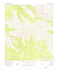
1958 Map of Big Delta C-1
USGS Topo · Published 1973About this map
Goodpaster River and the Charley River define the drainage patterns of this remote interior Alaska landscape, as surveyed in the mid-1950s. The terrain is characterized by a complex network of high-elevation ridges and deep creek valleys, including Stone Boy Creek and Paldo Creek in the northern reaches. This 1958 field-annotated map captures the region before extensive modern development, showing unsurveyed land lines predetermined by the Bureau of Land Management. The boundary of the Fairbanks North Star Borough cuts through the western portion of the quadrangle, crossing Porcupine Creek. Other notable watercourses such as Slate Creek and Rock Creek serve as primary landmarks in a territory devoid of established roads or permanent settlements at the time of this survey.
Find a feature on this map
8 named features on this map. Tap any name to fly to it.
Don’t see what you’re looking for? This feature index may not catch every label — zoom into the map to look around manually.
Map Details
Editions of this 1958 Big Delta C-1 Map
2 editions found

Other maps of this area

1950 · Big Delta
USGS Topo · 1:250,000

1951 · Big Delta
USGS Topo · 1:250,000

1951 · Eagle
USGS Topo · 1:250,000

1956 · Eagle C-6
USGS Topo · 1:63,360

1956 · Eagle B-6
USGS Topo · 1:63,360
1956 · Eagle D-6
USGS Topo · 1:63,360

1957 · Eagle
USGS Topo · 1:250,000

1958 · Big Delta B-2
USGS Topo · 1:63,360

1958 · Big Delta B-1
USGS Topo · 1:63,360

1958 · Big Delta D-2
USGS Topo · 1:63,360