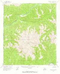
1958 Map of Big Delta C-2
USGS Topo · Published 1967About this map
The Salcha River snakes through the northern drainage of this interior Alaska landscape, while the Goodpaster River marks the southern extent of the surveyed area. Mapping conducted in the mid-1950s highlights a wilderness largely devoid of permanent development, save for a solitary Cabin located along Maiden Creek. The topography is dominated by the complex watershed systems of Porcupine Creek and the bifurcated Upper Boulder and Lower Boulder creeks. The transition of administrative lines is visible through the North Star Borough Boundary, which bisects the southern half of the quadrangle. This survey captures a moment of topographical record before significant modern change, focusing on the intricate drainages of Glacier Creek and Indian Creek that define the high-relief terrain.
Find a feature on this map
11 named features on this map. Tap any name to fly to it.
Don’t see what you’re looking for? This feature index may not catch every label — zoom into the map to look around manually.
Map Details
Editions of this 1958 Big Delta C-2 Map
2 editions found
Other maps of this area

1950 · Big Delta
USGS Topo · 1:250,000

1951 · Big Delta
USGS Topo · 1:250,000

1958 · Big Delta B-3
USGS Topo · 1:63,360

1958 · Big Delta C-3
USGS Topo · 1:63,360

1958 · Big Delta D-3
USGS Topo · 1:63,360

1958 · Big Delta B-2
USGS Topo · 1:63,360

1958 · Big Delta B-1
USGS Topo · 1:63,360

1958 · Big Delta D-2
USGS Topo · 1:63,360

1958 · Big Delta D-1
USGS Topo · 1:63,360

1958 · Big Delta C-2
USGS Topo · 1:63,360