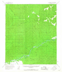
1958 Map of Big Delta C-5
USGS Topo · Published 1967About this map
The Military Reservation occupies much of the northern half of this terrain, where the South Fork Chena River and its tributaries like Stuart Creek and Pines Creek drain the interior uplands. Evidence of early aviation and transport in the subarctic is visible through a remote Landing Strip and a Tractor Trail that meanders through the southern river valleys.
Find a feature on this map
18 named features on this map. Tap any name to fly to it.
Don’t see what you’re looking for? This feature index may not catch every label — zoom into the map to look around manually.
Map Details
Editions of this 1958 Big Delta C-5 Map
4 editions found

Other maps of this area

1949 · Big Delta B-5
USGS Topo · 1:63,360

1949 · Big Delta B-6
USGS Topo · 1:63,360

1949 · Big Delta C-6
USGS Topo · 1:63,360

1950 · Big Delta
USGS Topo · 1:250,000

1950 · Big Delta D-6
USGS Topo · 1:63,360

1950 · Big Delta B-4
USGS Topo · 1:63,360

1951 · Big Delta
USGS Topo · 1:250,000

1952 · Big Delta C-6
USGS Topo · 1:63,360

1952 · Big Delta D-6
USGS Topo · 1:63,360

1952 · Big Delta B-6
USGS Topo · 1:63,360