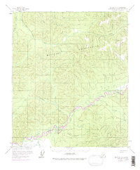
1958 Map of Big Delta C-5
USGS Topo · Published 1972About this map
The Military Reservation dominates the center of this 1:63,360 scale survey, covering a vast interior expanse between the South Fork Chena River to the north and the Salcha River to the south. The landscape is defined by its drainage networks, where Stuart Creek and Emory Creek carve through high terrain. Human activity is sparse and primarily utilitarian, evidenced by a Landing Strip and a network of a Tractor Trail that follows the river valleys.
Find a feature on this map
17 named features on this map. Tap any name to fly to it.
Don’t see what you’re looking for? This feature index may not catch every label — zoom into the map to look around manually.
Map Details
Editions of this 1958 Big Delta C-5 Map
4 editions found

Other maps of this area

1949 · Big Delta B-5
USGS Topo · 1:63,360

1949 · Big Delta B-6
USGS Topo · 1:63,360

1949 · Big Delta C-6
USGS Topo · 1:63,360

1950 · Big Delta
USGS Topo · 1:250,000

1950 · Big Delta D-6
USGS Topo · 1:63,360

1950 · Big Delta B-4
USGS Topo · 1:63,360

1951 · Big Delta
USGS Topo · 1:250,000

1952 · Big Delta C-6
USGS Topo · 1:63,360

1952 · Big Delta D-6
USGS Topo · 1:63,360

1952 · Big Delta B-6
USGS Topo · 1:63,360