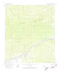
1958 Map of Big Delta C-5
USGS Topo · Published 1974About this map
The Salcha River and the South Fork Chena River dominate this interior Alaskan landscape, which was primarily defined by its remoteness and strategic utility during the mid-20th century. A massive Military Reservation occupies the central portion of the map, illustrating the significant federal footprint in the Fairbanks North Star Borough during the Cold War. Transportation across this wilderness was limited to a few specific corridors, most notably the Tractor Trail that parallels the Salcha River and its various tributaries. Small clusters of Cabins and a remote Landing Strip indicate seasonal or specialized activity in an area otherwise devoid of concentrated settlement. Hydrological features like Koepke Slough and Twentyfive Mile Creek provide specific landmarks for those navigating the complex river systems and lowlands that characterize this subarctic terrain.
Find a feature on this map
17 named features on this map. Tap any name to fly to it.
Don’t see what you’re looking for? This feature index may not catch every label — zoom into the map to look around manually.
Map Details
Editions of this 1958 Big Delta C-5 Map
4 editions found

Other maps of this area

1949 · Big Delta B-5
USGS Topo · 1:63,360

1949 · Big Delta B-6
USGS Topo · 1:63,360

1949 · Big Delta C-6
USGS Topo · 1:63,360

1950 · Big Delta
USGS Topo · 1:250,000

1950 · Big Delta D-6
USGS Topo · 1:63,360

1950 · Big Delta B-4
USGS Topo · 1:63,360

1951 · Big Delta
USGS Topo · 1:250,000

1952 · Big Delta C-6
USGS Topo · 1:63,360

1952 · Big Delta D-6
USGS Topo · 1:63,360

1952 · Big Delta B-6
USGS Topo · 1:63,360