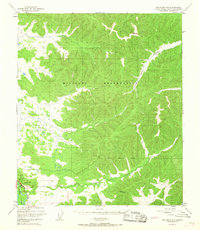
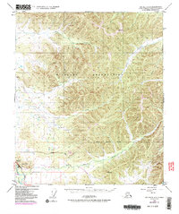
1949 Map of Big Delta C-6
USGS Topo · Published 1967About this map
The Military Reservation dominates the interior of this Alaskan interior landscape, a vast expanse of high terrain and drainage systems surveyed just after the war. The topography is defined by the winding course of the Little Salcha River and its numerous tributaries, including Moose Creek, Globe Creek, and Stuart Creek. In the southwest corner, the Tanana River cuts across the landscape, paralleled by the vital transport corridor of the Richardson Highway. This 1949 survey, with minor revisions in the mid-1960s, reveals a largely uninhabited territory where movement was dictated by the river valleys and the few established survey markers like VABM 2556 Seven and VABM 1831 Canyon. The map provides a clear record of the area's transition into a specialized military and transportation zone, showcasing the isolation of the French Creek drainage within the larger restricted boundaries.
Find a feature on this map
11 named features on this map. Tap any name to fly to it.
Don’t see what you’re looking for? This feature index may not catch every label — zoom into the map to look around manually.
Map Details
Editions of this 1949 Big Delta C-6 Map
6 editions found
Other maps of this area

1949 · Fairbanks D-1
USGS Topo · 1:62,500

1949 · Big Delta B-5
USGS Topo · 1:63,360

1949 · Big Delta B-6
USGS Topo · 1:63,360

1949 · Fairbanks C-1
USGS Topo · 1:63,360

1949 · Big Delta C-6
USGS Topo · 1:63,360

1950 · Fairbanks
USGS Topo · 1:250,000

1950 · Big Delta
USGS Topo · 1:250,000

1950 · Big Delta D-6
USGS Topo · 1:63,360

1950 · Fairbanks C-1
USGS Topo · 1:63,360

1950 · Fairbanks B-1
USGS Topo · 1:63,360