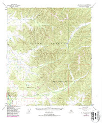
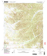
1949 Map of Big Delta C-6
USGS Topo · Published 1987About this map
The Tanana River and the sweeping infrastructure of the mid-20th century define this landscape in the Big Delta region. A large Military Reservation occupies the central and northern reaches, where the terrain is marked by remote drainage systems like Stuart Creek and Moose Creek. While the topography is based on 1949 surveys, purple revisions added in 1975 highlight the arrival of modern industry, most notably The Trans-Alaska Pipeline cutting across the southwestern corner. Transportation networks are concentrated near the river, following the Richardson Highway and Johnson Road. These corridors reveal the functional layout of the territory, including a Pumping Station and a Landing Strip, reflecting the shift from a landscape defined by natural waterways and survey markers like VABM Seven 2566 to one shaped by strategic energy and defense needs.
Find a feature on this map
18 named features on this map. Tap any name to fly to it.
Don’t see what you’re looking for? This feature index may not catch every label — zoom into the map to look around manually.
Map Details
Editions of this 1949 Big Delta C-6 Map
6 editions found
Other maps of this area

1949 · Fairbanks D-1
USGS Topo · 1:62,500

1949 · Big Delta B-5
USGS Topo · 1:63,360

1949 · Big Delta B-6
USGS Topo · 1:63,360

1949 · Fairbanks C-1
USGS Topo · 1:63,360

1949 · Big Delta C-6
USGS Topo · 1:63,360

1950 · Fairbanks
USGS Topo · 1:250,000

1950 · Big Delta
USGS Topo · 1:250,000

1950 · Big Delta D-6
USGS Topo · 1:63,360

1950 · Fairbanks C-1
USGS Topo · 1:63,360

1950 · Fairbanks B-1
USGS Topo · 1:63,360