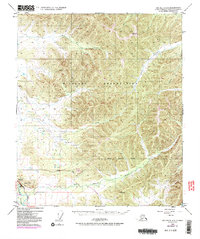
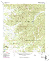
1949 Map of Big Delta C-6
USGS Topo · Published 1987About this map
Military Reservation lands dominate this interior Alaskan landscape, which reflects several decades of logistical and industrial development. While the terrain was originally mapped in the late 1940s, this edition includes significant post-war infrastructure. The most striking addition is The Trans-Alaska Pipeline, which cuts through the southern portion of the quadrangle near a dedicated Pumping Station. This vital energy corridor runs parallel to the Richardson Highway, the region's primary artery connecting the interior to the coast.
Find a feature on this map
15 named features on this map. Tap any name to fly to it.
Don’t see what you’re looking for? This feature index may not catch every label — zoom into the map to look around manually.
Map Details
Editions of this 1949 Big Delta C-6 Map
6 editions found
Other maps of this area

1949 · Fairbanks D-1
USGS Topo · 1:62,500

1949 · Big Delta B-5
USGS Topo · 1:63,360

1949 · Big Delta B-6
USGS Topo · 1:63,360

1949 · Fairbanks C-1
USGS Topo · 1:63,360

1949 · Big Delta C-6
USGS Topo · 1:63,360

1950 · Fairbanks
USGS Topo · 1:250,000

1950 · Big Delta
USGS Topo · 1:250,000

1950 · Big Delta D-6
USGS Topo · 1:63,360

1950 · Fairbanks C-1
USGS Topo · 1:63,360

1950 · Fairbanks B-1
USGS Topo · 1:63,360