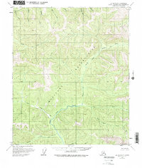
1973 Map of Big Delta D-3
USGS Topo · Published 1975About this map
The North Fork Salcha River and its numerous tributaries dominate this mid-century topographic view of the Alaskan interior. This era in the Fairbanks North Star Borough reveals a landscape defined by sharp elevation changes and the significant presence of a Military Reservation stretching across the central and southern portions of the quadrangle. The interior's remote character is emphasized by the sparse human development, with only a solitary Cabin noted near the river's path.
Find a feature on this map
24 named features on this map. Tap any name to fly to it.
Don’t see what you’re looking for? This feature index may not catch every label — zoom into the map to look around manually.
Map Details
Editions of this 1973 Big Delta D-3 Map
This is the sole edition of this map. No revisions or reprints were ever made.
Other maps of this area

1950 · Big Delta
USGS Topo · 1:250,000

1951 · Big Delta
USGS Topo · 1:250,000

1951 · Circle
USGS Topo · 1:250,000

1952 · Circle A-4
USGS Topo · 1:63,360

1955 · Circle A-2
USGS Topo · 1:63,360

1955 · Circle A-3
USGS Topo · 1:63,360

1955 · Circle
USGS Topo · 1:250,000

1958 · Big Delta C-4
USGS Topo · 1:63,360

1958 · Big Delta D-4
USGS Topo · 1:63,360

1958 · Big Delta C-3
USGS Topo · 1:63,360