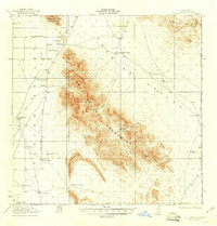
1918 Map of Big Hatchet Peak
USGS Topo · Published 1937About this map
Big Hatchet Peak dominates this arid landscape at the southwestern corner of New Mexico, where the Big Hatchet Mountains rise sharply between the Playas Valley and Hatchita Valley. Surveyed in 1917-1918, the map documents a sparse ranching economy dependent on reliable water sources like Las Cienegas Spring and Whitewater Wells. The map highlights a network of family-named outposts and windmills, including Lambert Ranch, Worthington Ranch, and Chaineys Ranch, many of which were connected by the primitive Hachita and Mexico Road. This infrastructure underscores the isolation of the borderlands during the early 20th century, where deep canyons such as Thompson Canyon and Sheridan Canyon provided the only breaks in the desert terrain. To the south, the map clearly delineates the United States Mexico international boundary, marking the transition into the Mexican state of Chihuahua.
Find a feature on this map
40 named features on this map. Tap any name to fly to it.
Don’t see what you’re looking for? This feature index may not catch every label — zoom into the map to look around manually.
Map Details
Editions of this 1918 Big Hatchet Peak Map
5 editions found
Other maps of this area

1917 · Antelope Wells
USGS Topo · 1:62,500

1918 · Big Hatchet Peak
USGS Topo · 1:62,500

1918 · Hachita
USGS Topo · 1:62,500

1918 · Dog Mountains
USGS Topo · 1:62,500

1918 · Walnut Wells
USGS Topo · 1:62,500

1918 · Victorio
USGS Topo · 1:62,500

1918 · Playas
USGS Topo · 1:62,500

1919 · Playas
USGS Topo · 1:62,500

1919 · Antelope Wells
USGS Topo · 1:62,500

1923 · Walnut Wells
USGS Topo · 1:62,500