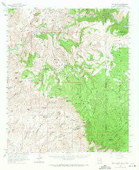
1962 Map of Big Lue Mts
USGS Topo · Published 1971About this map
The San Francisco River and Blue River converge in this high-elevation wilderness along the border of Arizona and New Mexico. This 1962 field-checked survey reveals a landscape primarily defined by the Gila National Forest and the Big Lue Mts, where numerous springs and stock tanks like Maverick Spring and Salt Ground Tank supported ranching operations. The presence of a Cliff Dwelling near the river suggests a long history of human habitation predating the modern cattle era. Movement through the complex canyons is marked by numerous Jeep Trails and significant passes such as Sixshooter Gap and Stockton Gap. The mapping of the Big Lue Ranch and local peaks like McMullen Peak and Chalk Peak provides a clear view of the mid-century geography of Greenlee County, Arizona, and Catron County, New Mexico.
Find a feature on this map
126 named features on this map. Tap any name to fly to it.
Don’t see what you’re looking for? This feature index may not catch every label — zoom into the map to look around manually.
Map Details
Editions of this 1962 Big Lue Mts Map
2 editions found

Other maps of this area

1902 · Clifton
USGS Topo · 1:62,500

1910 · Mogollon
USGS Topo · 1:125,000

1912 · Mogollon
USGS Topo · 1:125,000

1913 · Morenci
USGS Topo · 1:125,000

1915 · Morenci
USGS Topo · 1:125,000

1954 · Silver City
USGS Topo · 1:250,000

1954 · Clifton
USGS Topo · 1:250,000

1957 · Clifton
USGS Topo · 1:250,000

1958 · Silver City
USGS Topo · 1:250,000

1958 · Clifton
USGS Topo · 1:250,000