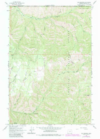
1963 Map of Big Meadows
USGS Topo · Published 1983About this map
The Umatilla National Forest defines the rugged geography of this 1963 survey, where the North Fork Walla Walla River carves deep into the terrain. A notable bend known as The Horseshoe and landmarks like Blalock Mountain anchor the southern reach of the quadrangle. Early 1960s land use is visible through the presence of a Mine and Mill along Mill Creek in the north, indicating small-scale resource extraction near the Walla Walla Co Umatilla Co line. The map highlights a network of remote access routes, including the Intake (Pack) Trail and Government Mountain Road, which link seasonal sites like Kiwanis Camp to the wider landscape. Significant open spaces like Big Meadows and Little Meadow Canyon break up the timbered ridges, providing a clear record of the watershed and forest management practices before the 1980s revisions.
Find a feature on this map
31 named features on this map. Tap any name to fly to it.
Don’t see what you’re looking for? This feature index may not catch every label — zoom into the map to look around manually.
Map Details
Editions of this 1963 Big Meadows Map
5 editions found

Other maps of this area

1919 · Walla Walla
USGS Topo · 1:125,000

1921 · Walla Walla
USGS Topo · 1:125,000

1937 · Pomeroy
USGS Topo · 1:96,000

1942 · Pomeroy
USGS Topo · 1:125,000

1953 · Pendleton
USGS Topo · 1:250,000

1953 · Walla Walla
USGS Topo · 1:250,000

1955 · Pullman
USGS Topo · 1:250,000

1955 · Grangeville
USGS Topo · 1:250,000

1956 · Pendleton
USGS Topo · 1:250,000

1958 · Pullman
USGS Topo · 1:250,000