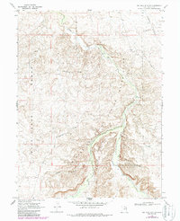
1968 Map of Big Pack Mtn. NW
USGS Topo · Published 1987About this map
The Uintah and Ouray Indian Reservation boundary cuts through this high desert landscape, defining a region where industrial energy extraction meets traditional topography. Much of the western portion is dominated by the Island Gas Field, marked by numerous Gas Wells and a network of both buried and aboveground pipelines. The serpentine path of Willow Creek carves a deep valley through the center of the map, providing a vital water source and geographic corridor for the Black Bridge and Squaw Crossing.
Find a feature on this map
19 named features on this map. Tap any name to fly to it.
Don’t see what you’re looking for? This feature index may not catch every label — zoom into the map to look around manually.
Map Details
Editions of this 1968 Big Pack Mtn. NW Map
Other maps of this area

1885 · East Tavaputs
USGS Topo · 1:250,000

1885 · Ashley
USGS Topo · 1:250,000

1917 · Vernal
USGS Topo · 1:125,000

1953 · Nutters Hole
USGS Topo · 1:62,500

1954 · Vernal
USGS Topo · 1:250,000

1956 · Grand Junction
USGS Topo · 1:250,000

1958 · Vernal
USGS Topo · 1:250,000

1959 · Grand Junction
USGS Topo · 1:250,000

1960 · Vernal
USGS Topo · 1:250,000

1960 · Grand Junction
USGS Topo · 1:250,000