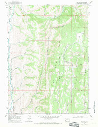
1967 Map of Big Park
USGS Topo · Published 1971About this map
The Tunp Range and Middle Ridge dominate this section of western Wyoming, where high-altitude meadows and dense drainage networks define the terrain. In the late 1960s, this area remained largely remote, anchored by the Kelley Guard Sta and the northern reaches of the Bridger National Forest. The map documents a rugged landscape utilized for both forestry and early exploration, evidenced by scattered prospects near Ferney Gulch and a lonely grave located south of Button Flat. Water management and natural flow are central to the region, with the Smiths Fork and Hams Fork serving as primary arteries. High mountain clearings like Big Park and Jap Park suggest seasonal grazing or traditional high-country usage patterns, while a network of named hollows including Preacher Hollow and Bloom Hollow provide a localized sense of place within the complex topography of Lincoln County.
Find a feature on this map
43 named features on this map. Tap any name to fly to it.
Don’t see what you’re looking for? This feature index may not catch every label — zoom into the map to look around manually.
Map Details
Editions of this 1967 Big Park Map
2 editions found
Other maps of this area

1936 · Cokeville
USGS Topo · 1:96,000

1942 · Cokeville
USGS Topo · 1:125,000

1955 · Preston
USGS Topo · 1:250,000

1958 · Preston
USGS Topo · 1:250,000

1962 · Preston
USGS Topo · 1:250,000
1967 · Pole Creek
USGS Topo · 1:24,000

1967 · Devils Hole Creek
USGS Topo · 1:24,000

1967 · Graham Peak
USGS Topo · 1:24,000

1967 · Big Park
USGS Topo · 1:24,000

1967 · Huff Lake
USGS Topo · 1:24,000