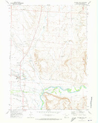
1970 Map of Big Piney East
USGS Topo · Published 1973About this map
Big Piney and Marbleton serve as the primary hubs in this Sublette County landscape during the early 1970s. The map illustrates a complex water management system essential for high-desert agriculture, featuring an extensive network of irrigation works like the Highline Canal, Sage Ditch, and Tarter Ditch. A notable historical layer is the presence of the Emigrant Trail (Lander Cutoff), which cuts diagonally across the township lines, tracing the path of nineteenth-century wagon travel through the basin. Along the Green River, a Ferry and the Three Bridges crossing near Island highlight the critical transit points for crossing the waterway. The area's mid-century economic activities are reflected in features such as the Big Piney Municipal Airport, the Fairground, and various resource markers like Meadow Canyon Well No 1 and a Gravel Pit.
Find a feature on this map
45 named features on this map. Tap any name to fly to it.
Don’t see what you’re looking for? This feature index may not catch every label — zoom into the map to look around manually.
Map Details
Editions of this 1970 Big Piney East Map
2 editions found
Other maps of this area

1939 · Big Piney
USGS Topo · 1:125,000

1942 · Big Piney
USGS Topo · 1:125,000

1955 · Preston
USGS Topo · 1:250,000

1955 · Lander
USGS Topo · 1:250,000

1958 · Lander
USGS Topo · 1:250,000

1958 · Preston
USGS Topo · 1:250,000

1961 · Lander
USGS Topo · 1:250,000

1962 · Preston
USGS Topo · 1:250,000

1964 · Ross Butte
USGS Topo · 1:24,000

1964 · Mesa Spring
USGS Topo · 1:24,000