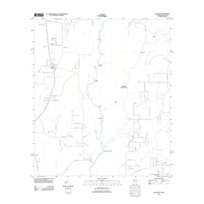
2012 Map of Big Point
USGS Topo · Published 2012About this map
The Escatawpa River defines the central axis of this landscape, its winding course marked by a series of prominent riverine landmarks including Cowards Bluff, Sikes Bluff, and Rubenhouse Bluff. Along the eastern and western banks, a complex network of wetlands and oxbows has formed features such as Petes Lake, Sapling Pond, and Fiddlers Sail. This 2012 survey illustrates the scattered settlement patterns of Big Point and Cloverdale near the Alabama-Mississippi border, where residential growth is integrated into a landscape of timber and traditional landholdings. Local history and genealogy are well-represented by numerous burial sites, including Big Point Cem, Tates Cem, and Forts Lake Cem. Further south, the map details the confluence of Jackson Cr and the river, near the small community of Cloverdale. The area also features recreational developments like the Whispering Pines Golf Course and East Central County Golf Course, contrasting with the more rural river landings like Galloway Landing.
Find a feature on this map
113 named features on this map. Tap any name to fly to it.
Don’t see what you’re looking for? This feature index may not catch every label — zoom into the map to look around manually.
Map Details
Editions of this 2012 Big Point Map
This is the sole edition of this map. No revisions or reprints were ever made.
Other maps of this area

1921 · Grand Bay
USGS Topo · 1:62,500

1941 · Hurley
USGS Topo · 1:62,500

1941 · Vancleave
USGS Topo · 1:62,500

1943 · Pascagoula
USGS Topo · 1:62,500

1943 · Grand Bay
USGS Topo · 1:62,500

1943 · Hurley
USGS Topo · 1:62,500

1943 · Vancleave
USGS Topo · 1:62,500

1944 · Vancleave
USGS Topo · 1:62,500

1953 · Mobile
USGS Topo · 1:250,000

1955 · Pascagoula
USGS Topo · 1:62,500