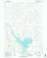
1969 Map of Big Sandy Reservoir
USGS Topo · Published 1995About this map
Big Sandy River winds through the high desert landscape of Wyoming, captured here just as the waters of the Big Sandy Reservoir were being managed for recreation and irrigation. This 1960s survey illustrates the shoreline at an elevation of 6758 feet, highlighting the newly established Big Sandy State Recreation Area that surrounds the water. The map documents hydraulic infrastructure essential to the region's development, including the Big Sandy Dam at the southern end and a Gaging Sta to the north. Straddling the border between Sublette Co and Sweetwater Co, the terrain shows a sparse but functional network of trails and light-duty roads that provide access to points like the Flowing Well. For researchers, the map provides a clear record of the high-plains water management and early recreational development in this corner of the state.
Find a feature on this map
7 named features on this map. Tap any name to fly to it.
Don’t see what you’re looking for? This feature index may not catch every label — zoom into the map to look around manually.
Map Details
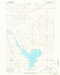
Editions of this 1969 Big Sandy Reservoir Map
2 editions found
Other maps of this area

1955 · Lander
USGS Topo · 1:250,000

1958 · Lander
USGS Topo · 1:250,000

1961 · Lander
USGS Topo · 1:250,000

1968 · Eden Reservoir East
USGS Topo · 1:24,000
1968 · Eden Reservoir West
USGS Topo · 1:24,000
1968 · Fourmile Knoll
USGS Topo · 1:24,000
1969 · Juel Spring
USGS Topo · 1:24,000

1969 · Leckie Reservoir
USGS Topo · 1:24,000
1969 · Bull Draw
USGS Topo · 1:24,000

1969 · Tabernacle Butte
USGS Topo · 1:24,000