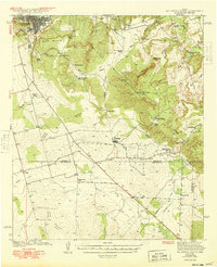
1941 Map of Big Spring South
USGS Topo · Published 1949About this map
The southern outskirts of Big Spring give way to a landscape defined by livestock ranching and prominent geological landmarks like South Mountain and Signal Peak. Surveyed just before the decade began, this map shows a West Texas environment where water sources like Moss Spring and the Big Spring City Water Wells were vital for both the city and the surrounding cattle operations. The Texas & Pacific RR cuts through the northern edge, connecting the county seat to broader markets, while smaller settlements such as Forsan and Ross City serve as hubs for the local rural population. Scattered schools including Chalk Sch and Panther Draw Sch indicate the distribution of farming and ranching families across the terrain, which is segmented by the Watershed Divide between the Colorado Concho and Beals Creek.
Find a feature on this map
44 named features on this map. Tap any name to fly to it.
Don’t see what you’re looking for? This feature index may not catch every label — zoom into the map to look around manually.
Map Details
Editions of this 1941 Big Spring South Map
2 editions found
Other maps of this area

1941 · Morita
USGS Topo · 1:62,500

1941 · Big Spring South
USGS Topo · 1:62,500

1942 · Big Spring South
USGS Topo · 1:62,500

1942 · Big Spring North
USGS Topo · 1:62,500

1949 · Morita
USGS Topo · 1:62,500

1951 · Iatan
USGS Topo · 1:24,000

1952 · Iatan
USGS Topo · 1:24,000

1954 · Big Spring
USGS Topo · 1:250,000

1954 · San Angelo
USGS Topo · 1:250,000

1954 · Big Spring North
USGS Topo · 1:24,000