
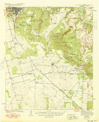
1941 Map of Big Spring South
USGS Topo · Published 1949About this map
Big Spring sits at the northern edge of this West Texas landscape, which drops south from the high plains into the breaks of the Signal Mountains. Surveyed in the late 1930s, the map reveals a region defined by scattered livestock operations and the emergence of the local oil industry. Small rural communities like Forsan and the cluster at Ross City serve as anchors between the sprawling ranches, including the Wasson Ranch, Morgan Ranch, and West Ranch. A series of country schools like Chalk Sch and Panther Draw Sch indicate a distributed population during this era, while the Big Spring City Water Wells highlight the critical importance of groundwater in this semi-arid environment. The terrain is marked by the Watershed Divide that separates the drainage of Beals Creek from the headwaters of the Colorado Concho to the south.
Find a feature on this map
40 named features on this map. Tap any name to fly to it.
Don’t see what you’re looking for? This feature index may not catch every label — zoom into the map to look around manually.
Map Details
Editions of this 1941 Big Spring South Map
2 editions found
Other maps of this area

1941 · Morita
USGS Topo · 1:62,500

1942 · Big Spring South
USGS Topo · 1:62,500

1942 · Big Spring North
USGS Topo · 1:62,500

1949 · Morita
USGS Topo · 1:62,500

1951 · Iatan
USGS Topo · 1:24,000

1952 · Iatan
USGS Topo · 1:24,000

1954 · Big Spring
USGS Topo · 1:250,000

1954 · San Angelo
USGS Topo · 1:250,000

1954 · Big Spring North
USGS Topo · 1:24,000

1958 · San Angelo
USGS Topo · 1:250,000