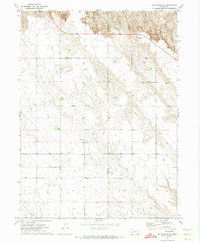
1971 Map of Big Springs NE
USGS Topo · Published 1974About this map
The Oregon Trail cuts a historic path through this portion of the Nebraska panhandle, following the natural contours of the Platte River valley's northern bluffs. This 1971 survey captures a landscape defined by the intersection of westward expansion routes and modern infrastructure. The rugged terrain transitions from high prairie plateaus in Garden and Deuel counties down to the lower sandy flats. Modern utility development is visible through the presence of a natural gas Pipeline and Radio Towers positioned on the high ground for maximum signal reach. Local transit is facilitated by Day Road, which serves the agricultural interests of the region. The map reflects a sparsely populated area where land use is dominated by large-scale ranching or farming, indicated by the numerous wells scattered across the lower elevations to support livestock and irrigation in this semi-arid environment.
Find a feature on this map
8 named features on this map. Tap any name to fly to it.
Don’t see what you’re looking for? This feature index may not catch every label — zoom into the map to look around manually.
Map Details
Editions of this 1971 Big Springs NE Map
This is the sole edition of this map. No revisions or reprints were ever made.
Other maps of this area

1897 · Ogallala
USGS Topo · 1:125,000

1900 · Chappell
USGS Topo · 1:125,000

1900 · Ogallala
USGS Topo · 1:125,000

1954 · Scottsbluff
USGS Topo · 1:250,000

1954 · North Platte
USGS Topo · 1:250,000

1956 · North Platte
USGS Topo · 1:250,000

1957 · North Platte
USGS Topo · 1:250,000

1958 · Scottsbluff
USGS Topo · 1:250,000

1961 · Barton
USGS Topo · 1:24,000

1961 · Big Springs
USGS Topo · 1:24,000