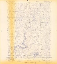
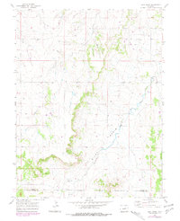
1970 Map of Bijou Basin
USGS Topo · Published 1973About this map
Bijou Basin Cem stands as a quiet focal point in this 1970 landscape, situated near the western edge of the Bijou Basin. The terrain is defined by the significant drainage patterns of West Bijou Creek and Comanche Creek, which carve through the high plains of the Elbert Co and El Paso Co border. While primarily an agricultural or open landscape, the map reveals early industrial activity through scattered infrastructure like the Oil Well, several Drill Hole sites, and a Gravel Pit. The presence of these resource extraction points alongside a solitary Knob illustrates the varied economic and geological character of this region of Colorado as it transitioned through the mid-century.
Find a feature on this map
9 named features on this map. Tap any name to fly to it.
Don’t see what you’re looking for? This feature index may not catch every label — zoom into the map to look around manually.
Map Details
Editions of this 1970 Bijou Basin Map
5 editions found
Other maps of this area

1894 · Castle Rock
USGS Topo · 1:125,000

1913 · Castle Rock
USGS Topo · 1:125,000

1939 · Elizabeth
USGS Topo · 1:62,500

1940 · Elbert
USGS Topo · 1:62,500

1944 · Elbert
USGS Topo · 1:62,500

1945 · Elizabeth
USGS Topo · 1:62,500

1953 · Denver
USGS Topo · 1:250,000
1954 · Eastonville
USGS Topo · 1:24,000

1957 · Denver
USGS Topo · 1:250,000

1958 · Denver
USGS Topo · 1:250,000