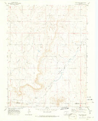
1970 Map of Bijou Basin
USGS Topo · Published 1973About this map
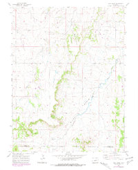
The Bijou Basin dominates this landscape along the border of Elbert and El Paso Counties, where the high plains terrain is carved by the drainages of Comanche Creek and West Bijou Creek. This 1970 field-checked survey reveals a sparsely populated ranching and resource area, characterized by family-named landmarks and small-scale industrial sites. The presence of the Bijou Basin Cem near the southern boundary provides a vital anchor for genealogists tracing early families in this portion of the basin. The map documents the mid-century transition toward varied land use, noting an Oil Well and a Drill Hole alongside traditional grazing lands. Geologic features like the Knob and a Gravel Pit further define the local topography, which is largely structured around the north-flowing creek beds that shaped the settlement patterns of this central Colorado region.
Find a feature on this map
10 named features on this map. Tap any name to fly to it.
Don’t see what you’re looking for? This feature index may not catch every label — zoom into the map to look around manually.
Map Details
Editions of this 1970 Bijou Basin Map
5 editions found
Other maps of this area

1894 · Castle Rock
USGS Topo · 1:125,000

1913 · Castle Rock
USGS Topo · 1:125,000

1939 · Elizabeth
USGS Topo · 1:62,500

1940 · Elbert
USGS Topo · 1:62,500

1944 · Elbert
USGS Topo · 1:62,500

1945 · Elizabeth
USGS Topo · 1:62,500

1953 · Denver
USGS Topo · 1:250,000
1954 · Eastonville
USGS Topo · 1:24,000

1957 · Denver
USGS Topo · 1:250,000

1958 · Denver
USGS Topo · 1:250,000