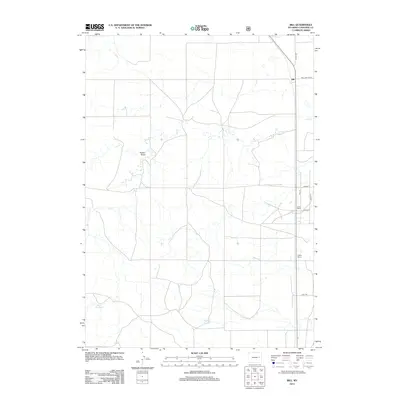
2012 Map of Bill
USGS Topo · Published 2012About this map
Bill serves as the primary focal point in this portion of Converse County, situated at a junction of regional importance. The settlement pattern is defined by traditional ranching operations, including Ireton Ranch and Oakley Ranch, which are linked by a network of local routes such as Steinle Rd and Dull Center Rd. The landscape is primarily shaped by the hydrology of the high plains, where ephemeral watercourses like Dry Cr and the drainage of Poison Draw carve through the terrain. Essential water management for agricultural use is evident through the presence of Rice Reservoir and Thomas Reservoir, reflecting the practical adaptations required for life in this part of Wyoming. These features illustrate the endurance of ranching life and the sparse, purposeful infrastructure of the region during the early twenty-first century.
Find a feature on this map
14 named features on this map. Tap any name to fly to it.
Don’t see what you’re looking for? This feature index may not catch every label — zoom into the map to look around manually.
Map Details
Editions of this 2012 Bill Map
This is the sole edition of this map. No revisions or reprints were ever made.
Other maps of this area

1955 · Newcastle
USGS Topo · 1:250,000

1958 · Newcastle
USGS Topo · 1:250,000

1959 · Bill
USGS Topo · 1:62,500

1959 · Betty Reservoir
USGS Topo · 1:62,500

1970 · Bill 4 NW
USGS Topo · 1:24,000
1970 · Bill 4 SW
USGS Topo · 1:24,000

1971 · Tin Can Lake
USGS Topo · 1:24,000

1979 · Bill
USGS Topo · 1:100,000
1984 · Bobby Draw
USGS Topo · 1:24,000
1984 · Patsy Draw
USGS Topo · 1:24,000