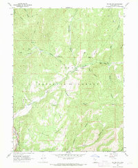
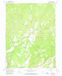
1967 Map of Billies Mtn.
USGS Topo · Published 1969About this map
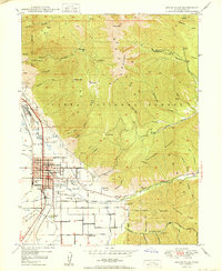
Billies Mountain dominates the southern landscape of this 1967 survey, where the rugged drainages of the Uinta National Forest meet the industrial corridors of the late 1960s. The southwestern corner is defined by the narrow passage of Spanish Fork Canyon, carrying the Spanish Fork River and the tracks of the D & R G W RR. This intersection of rail and river served as a vital transport artery through the central Utah peaks, while the interior of the map reveals a network of canyons including Wannhodes Canyon and Brimhall Canyon. Local history is marked by the Diamond Battle Historical Monument situated near Little Diamond Creek, a site of conflict between early settlers and the Ute people. Remote landmarks like Patrick Place and Wignal Spring offer evidence of grazing and homesteading activities tucked into the high country flats.
Find a feature on this map
34 named features on this map. Tap any name to fly to it.
Don’t see what you’re looking for? This feature index may not catch every label — zoom into the map to look around manually.
Map Details
Editions of this 1967 Billies Mtn. Map
3 editions found

Other maps of this area

1885 · Salt Lake
USGS Topo · 1:250,000

1885 · Manti
USGS Topo · 1:250,000

1895 · Manti
USGS Topo · 1:250,000

1907 · Strawberry Valley
USGS Topo · 1:125,000

1909 · Strawberry Valley
USGS Topo · 1:125,000
1948 · Springville
USGS Topo · 1:24,000

1949 · Provo
USGS Topo · 1:62,500
1949 · Spanish Fork Peak
USGS Topo · 1:24,000
1950 · Springville
USGS Topo · 1:24,000

1951 · Spanish Fork Peak
USGS Topo · 1:24,000