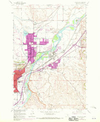
1956 Map of Billings East
USGS Topo · Published 1970About this map
The Yellowstone River and the steep escarpment of the Rimrocks dominate this mid-century view of the area surrounding Billings. The map documents a period of significant industrial and infrastructural development, visible in the presence of an Oil Refinery, the Burlington Northern railroad lines, and the extensive network of irrigation ditches such as those crossing the Billings Bench. This landscape is a hybrid of working industrial zones and established community landmarks, from the Yellowstone Fairgrounds near the river to the residential growth reflected in numerous local schools like Pioneer Sch and Hawthorn Sch.
Find a feature on this map
51 named features on this map. Tap any name to fly to it.
Don’t see what you’re looking for? This feature index may not catch every label — zoom into the map to look around manually.
Map Details
Editions of this 1956 Billings East Map
5 editions found
Other maps of this area

1893 · Huntley
USGS Topo · 1:125,000

1954 · Billings
USGS Topo · 1:250,000

1956 · Rattlesnake Butte
USGS Topo · 1:24,000

1956 · Hickson Ranch
USGS Topo · 1:24,000

1956 · Huntley
USGS Topo · 1:24,000

1956 · Yegen
USGS Topo · 1:24,000

1956 · Billings East
USGS Topo · 1:24,000

1957 · Billings
USGS Topo · 1:250,000

1957 · Billings West
USGS Topo · 1:24,000

1958 · Billings
USGS Topo · 1:250,000