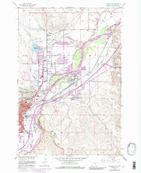
1956 Map of Billings East
USGS Topo · Published 1987About this map
The Yellowstone River anchors this mid-century look at Montana's growing rail and industrial hub, passing through a landscape defined by the steep Rimrocks and the prominent Sacrifice Cliff. The map reveals the expansion of Billings eastward toward Lockwood, with several Oil Refinery sites and the extensive Burlington Northern railyards marking the city's economic foundations. Rural heritage is visible in the network of irrigation infrastructure such as the Billings Bench Canal and McGirl Ditch, which supported the surrounding agriculture.
Find a feature on this map
44 named features on this map. Tap any name to fly to it.
Don’t see what you’re looking for? This feature index may not catch every label — zoom into the map to look around manually.
Map Details
Editions of this 1956 Billings East Map
5 editions found
Other maps of this area

1893 · Huntley
USGS Topo · 1:125,000

1954 · Billings
USGS Topo · 1:250,000

1956 · Rattlesnake Butte
USGS Topo · 1:24,000

1956 · Hickson Ranch
USGS Topo · 1:24,000

1956 · Huntley
USGS Topo · 1:24,000

1956 · Yegen
USGS Topo · 1:24,000

1956 · Billings East
USGS Topo · 1:24,000

1957 · Billings
USGS Topo · 1:250,000

1957 · Billings West
USGS Topo · 1:24,000

1958 · Billings
USGS Topo · 1:250,000