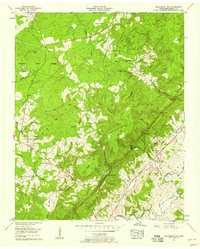
1956 Map of Billingsley Gap
USGS Topo · Published 1958About this map
The Cumberland Plateau drops sharply into the Sequatchie Valley in this mid-century survey of Bledsoe County. The landscape is defined by its dramatic elevation changes, where the high wooded expanse of Bledsoe State Forest and landmarks like Cowen Knob give way to fertile lowlands along the Sequatchie River. Settlement patterns follow the topography, with remote community centers such as Saratoga Springs and Tiptop on the heights, while the valley floor is dotted with small family farms and local institutions. Genealogists will find a wealth of local landmarks, from the Beaverhill Sch and Mt Crest Sch to numerous burial grounds including Blackburn Cem and Pendergrass Cem. This era shows the region before major modern expansion, preserving the locations of rural congregations like Wheeler Hill Ch and Smyrna Ch.
Find a feature on this map
58 named features on this map. Tap any name to fly to it.
Don’t see what you’re looking for? This feature index may not catch every label — zoom into the map to look around manually.
Map Details
Editions of this 1956 Billingsley Gap Map
3 editions found
Other maps of this area

1892 · Pikeville
USGS Topo · 1:125,000

1895 · Pikeville
USGS Topo · 1:125,000

1909 · Sequatchie Valley
USGS Topo · 1:62,500

1910 · Pikeville
USGS Topo · 1:62,500

1912 · Crossville
USGS Topo · 1:62,500

1935 · Melvine
USGS Topo · 1:24,000

1935 · Morgan Springs
USGS Topo · 1:24,000

1935 · Brockdell
USGS Topo · 1:24,000

1935 · Billingsley Gap
USGS Topo · 1:24,000
1935 · Vandever
USGS Topo · 1:24,000