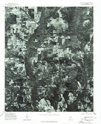
1975 Map of Billingsley SE
USGS Topo · Published 1977About this map
Booth serves as the primary landmark in this rural Autauga County landscape, captured in a mid-1970s orthophotoquad. Unlike traditional topographic maps, this aerial imagery provides a direct view of the land use patterns, revealing a patchwork of dense woodlands and cleared agricultural fields. The drainage of Bridge Creek carves a dark, winding path through the center of the image, where the thick riparian vegetation contrasts sharply with the geometric lines of managed timber and farm plots. This specific photographic survey offers researchers a clear look at the rural road network and the extent of forest cover before later decades of development and commercial forestry changed the local canopy.
Find a feature on this map
2 named features on this map. Tap any name to fly to it.
Don’t see what you’re looking for? This feature index may not catch every label — zoom into the map to look around manually.
Map Details
Editions of this 1975 Billingsley SE Map
This is the sole edition of this map. No revisions or reprints were ever made.
Other maps of this area

1891 · Clanton
USGS Topo · 1:125,000

1901 · Wetumpka
USGS Topo · 1:125,000

1903 · Wetumpka
USGS Topo · 1:125,000

1927 · Montgomery
USGS Topo · 1:48,000

1930 · Montgomery
USGS Topo · 1:62,500

1953 · Montgomery
USGS Topo · 1:250,000

1956 · Montgomery
USGS Topo · 1:250,000

1957 · Montgomery
USGS Topo · 1:250,000

1957 · Autaugaville
USGS Topo · 1:62,500

1958 · Montgomery
USGS Topo · 1:62,500