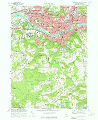
1968 Map of Binghamton West
USGS Topo · Published 1972About this map
The confluence of the Susquehanna River and Chenango River anchors this 1968 study of a bustling Southern Tier landscape. Commercial and residential density radiates from Binghamton and Johnson City, with the Erie-Lackawanna rail lines and new highway interchanges like Interchange 70 marking the era's infrastructure. To the south, the terrain rises toward Ingraham Hill and Table Rock Ridge, where the expanding State University of New York at Binghamton campus meets more rural reaches.
Find a feature on this map
77 named features on this map. Tap any name to fly to it.
Don’t see what you’re looking for? This feature index may not catch every label — zoom into the map to look around manually.
Map Details
Editions of this 1968 Binghamton West Map
Other maps of this area

1901 · Apalachin
USGS Topo · 1:62,500

1904 · Binghamton
USGS Topo · 1:62,500

1904 · Apalachin
USGS Topo · 1:62,500

1906 · Catatonk
USGS Topo · 1:125,000

1934 · Castle Creek
USGS Topo · 1:24,000

1935 · Binghamton West
USGS Topo · 1:24,000

1935 · Chenango Forks
USGS Topo · 1:24,000

1937 · Binghamton East
USGS Topo · 1:24,000

1942 · Binghamton West
USGS Topo · 1:31,680

1942 · Castle Creek
USGS Topo · 1:31,680