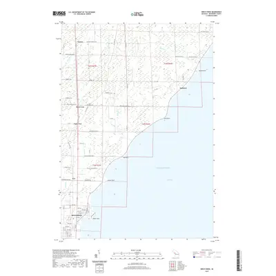
2019 Map of Birch Creek
USGS Topo · Published 2019About this map
The coastline of Lake Michigan along the Green Bay shore defines this portion of Menominee County, where the city of Menominee meets the marshy inlets and small drainages of the Upper Peninsula. Small settlements such as Birch Creek, Eagles Nest, and Ingallston are connected by a network of rural roads, including Co Hwy 571 and Bay De Noc Dr. The local geography is marked by numerous small streams like Beattie Cr, Springer Cr, and Birch Cr that empty into the bay near prominent landforms like Stony Point and Hall Point. In the southern reaches, the city grid of Menominee transitions into protected green space at Henes Park on Poplar Point. Local history is anchored by the Birch Creek Cem, providing a focal point for genealogical research in this coastal community.
Find a feature on this map
74 named features on this map. Tap any name to fly to it.
Don’t see what you’re looking for? This feature index may not catch every label — zoom into the map to look around manually.
Map Details
Editions of this 2019 Birch Creek Map
This is the sole edition of this map. No revisions or reprints were ever made.
Other maps of this area

1939 · Marinette
USGS Topo · 1:48,000

1949 · Stephenson
USGS Topo · 1:48,000

1954 · Escanaba
USGS Topo · 1:250,000

1957 · Escanaba
USGS Topo · 1:250,000

1958 · Escanaba
USGS Topo · 1:250,000

1961 · Chambers Island
USGS Topo · 1:62,500

1963 · Cedar River
USGS Topo · 1:62,500
1963 · Marinette West
USGS Topo · 1:24,000
1963 · Birch Creek
USGS Topo · 1:24,000
1963 · Chappee Rapids
USGS Topo · 1:24,000