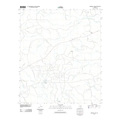
2010 Map of Birdwell Lake
USGS Topo · Published 2010About this map
Emille and its surrounding rural network in Tyler County anchor this landscape, where a complex web of county roads and creek branches defines the local geography. The area's hydrology is central to its layout, featuring Theuvenins Creek, Rush Creek, and Little Wolf Creek alongside several larger impoundments. Significant local landmarks include Birdwell Lake and Birdwell Lake Dam, located just west of a concentrated network of timber and access roads such as Antioch Rd and Old Emilie Rd. Genealogists and local historians can pinpoint Hopewell Cemetery situated near Push Creek in the eastern portion of the quadrangle. The map captures a detailed view of East Texas land management, evidenced by the Allison Lake Dam and the industrial footprint of the Tyler County Sanitary Land Fill Rd, reflecting the community's modern infrastructure and resource use.
Find a feature on this map
57 named features on this map. Tap any name to fly to it.
Don’t see what you’re looking for? This feature index may not catch every label — zoom into the map to look around manually.
Map Details
Editions of this 2010 Birdwell Lake Map
This is the sole edition of this map. No revisions or reprints were ever made.
Other maps of this area

1954 · Beaumont
USGS Topo · 1:250,000

1955 · Woodville
USGS Topo · 1:62,500

1955 · Curtis
USGS Topo · 1:62,500

1957 · Beaumont
USGS Topo · 1:250,000

1958 · Warren
USGS Topo · 1:62,500

1958 · Spurger
USGS Topo · 1:62,500

1984 · Beaumont
USGS Topo · 1:250,000
1984 · Woodville
USGS Topo · 1:24,000
1984 · Boggy Lake
USGS Topo · 1:24,000
1984 · Colmesneil
USGS Topo · 1:24,000