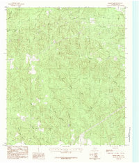
1984 Map of Boggy Lake
USGS Topo · Published 1984About this map
Boggy Lake serves as a central landmark in this Tyler County landscape, situated amidst a dense network of tributaries that feed into Boggy Creek. The map documents a predominantly rural environment defined by its hydrology, with naming conventions like Hopson Mill Creek and Tompkins Mill Creek suggesting the historical presence of water-powered industry along these drainage ways. A lone Graveyard located near Sulphur Creek and Sugar Branch provides a point of interest for genealogists tracing local family footprints. Modern utility infrastructure is represented by a Pipeline cutting diagonally across the terrain, while local industry is noted by a Gravel Pit in the western reaches. The intricate creek systems, including Snowden Spring Branch and the Clear Fork, illustrate the complex natural drainage patterns of this East Texas region during the late 1970s and early 1980s.
Find a feature on this map
25 named features on this map. Tap any name to fly to it.
Don’t see what you’re looking for? This feature index may not catch every label — zoom into the map to look around manually.
Map Details
Editions of this 1984 Boggy Lake Map
This is the sole edition of this map. No revisions or reprints were ever made.
Other maps of this area

1928 · Zavalla 3-c
USGS Topo · 1:24,000

1931 · Zavalla
USGS Topo · 1:62,500

1953 · Palestine
USGS Topo · 1:250,000

1954 · Beaumont
USGS Topo · 1:250,000

1955 · Woodville
USGS Topo · 1:62,500

1955 · Curtis
USGS Topo · 1:62,500

1957 · Beaumont
USGS Topo · 1:250,000

1957 · Palestine
USGS Topo · 1:250,000

1958 · Zavalla
USGS Topo · 1:62,500

1958 · Mc Gee Bend
USGS Topo · 1:62,500