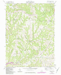
1961 Map of Birmingham
USGS Topo · Published 1984About this map
Birmingham and Peoli anchor this portion of the Tuscarawas Co Guernsey Co border, where rural life in the early 1960s was defined by small church congregations and country cemeteries. The landscape shows a deep connection to its educational and spiritual roots, evidenced by the combined Salem-Washington Sch and cemetery, alongside numerous other rural houses of worship like Irish Ridge Ch and Wesley Ch. To the south, the expansion of recreation is visible in the designated lands of Salt Fork State Park near Salt Fork Lake. The local economy of this era is etched into the terrain through a visible Strip Mine and an Oil Well near the Washington and Monroe township lines, while modern infrastructure is represented by a natural gas Pipeline cutting across the northwestern ridges.
Find a feature on this map
41 named features on this map. Tap any name to fly to it.
Don’t see what you’re looking for? This feature index may not catch every label — zoom into the map to look around manually.
Map Details
Editions of this 1961 Birmingham Map
Other maps of this area

1909 · Antrim
USGS Topo · 1:48,000

1909 · Uhrichsville
USGS Topo · 1:62,500

1909 · Cambridge
USGS Topo · 1:62,500

1911 · Antrim
USGS Topo · 1:62,500

1911 · Uhrichsville
USGS Topo · 1:62,500

1911 · Newcomerstown
USGS Topo · 1:62,500

1912 · Cambridge
USGS Topo · 1:62,500

1913 · Newcomerstown
USGS Topo · 1:62,500

1943 · Newcomerstown
USGS Topo · 1:62,500

1951 · Canton
USGS Topo · 1:250,000