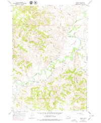
1967 Map of Birney
USGS Topo · Published 1979About this map
The Tongue River meanders through this portion of Rosebud County, serving as the lifeblood for a series of established cattle operations during the late 1960s. The landscape is defined by the sophisticated irrigation infrastructure required for ranching in this environment, including the Brown Cattle Co Ditch, Arnold Ditch, and Brewster W Side Ditch. These systems supported historic landholdings such as the Quarter Circle U Ranch, Brewster Ranch, and Mc Kinney Ranch.
Find a feature on this map
37 named features on this map. Tap any name to fly to it.
Don’t see what you’re looking for? This feature index may not catch every label — zoom into the map to look around manually.
Map Details
Editions of this 1967 Birney Map
2 editions found
Other maps of this area

1954 · Hardin
USGS Topo · 1:250,000

1957 · Hardin
USGS Topo · 1:250,000

1958 · Hardin
USGS Topo · 1:250,000

1966 · Browns Mountain
USGS Topo · 1:24,000

1966 · Birney Day School
USGS Topo · 1:24,000

1967 · Clubfoot Creek
USGS Topo · 1:24,000

1967 · Birney
USGS Topo · 1:24,000
1967 · Cook Creek Butte
USGS Topo · 1:24,000

1967 · Lacey Gulch
USGS Topo · 1:24,000
1967 · Spring Gulch
USGS Topo · 1:24,000