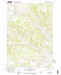
1967 Map of Birney SW
USGS Topo · Published 1971About this map
The Northern Cheyenne Indian Reservation Bdy bisects the northwestern portion of this landscape, marking a significant legal and cultural boundary between the reservation and Rosebud County and Big Horn County. In the late 1960s, this area remained largely undeveloped, characterized by the winding path of Prairie Dog Creek and numerous seasonal drainage features like Schoolhouse Draw and Bootlegger Draw. Settlement is sparse, anchored primarily by Brewster Camp in the north near the reservation line.
Find a feature on this map
20 named features on this map. Tap any name to fly to it.
Don’t see what you’re looking for? This feature index may not catch every label — zoom into the map to look around manually.
Map Details
Editions of this 1967 Birney SW Map
2 editions found
Other maps of this area

1954 · Hardin
USGS Topo · 1:250,000

1957 · Hardin
USGS Topo · 1:250,000

1958 · Hardin
USGS Topo · 1:250,000

1958 · Bull Creek Lookout
USGS Topo · 1:24,000

1967 · Clubfoot Creek
USGS Topo · 1:24,000

1967 · Birney
USGS Topo · 1:24,000

1967 · Tongue River Dam
USGS Topo · 1:24,000
1967 · Cook Creek Butte
USGS Topo · 1:24,000

1967 · Lacey Gulch
USGS Topo · 1:24,000
1967 · Spring Gulch
USGS Topo · 1:24,000