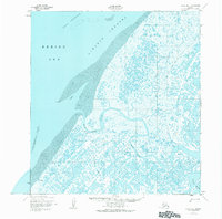
1952 Map of Black B-1
USGS Topo · Published 1984About this map
Black River meanders through a vast, water-logged delta landscape where the river system meets the Bering Sea. This mid-century coastal survey captures the intricate network of sloughs and passes, such as Kiangolévik Pass, that define the region's geography. Human presence is sparse but strategically placed along these vital waterways, anchored by the settlement at Black and several noted cabins that likely served as seasonal shelters for fishing or trapping.
Find a feature on this map
13 named features on this map. Tap any name to fly to it.
Don’t see what you’re looking for? This feature index may not catch every label — zoom into the map to look around manually.
Map Details
Editions of this 1952 Black B-1 Map
3 editions found
Other maps of this area

1951 · Black
USGS Topo · 1:250,000

1952 · Kwiguk
USGS Topo · 1:250,000

1952 · Black A-2
USGS Topo · 1:63,360
1952 · Black C-1
USGS Topo · 1:63,360

1952 · Black A-1
USGS Topo · 1:63,360

1952 · Black B-1
USGS Topo · 1:63,360

1952 · Kwiguk C-6
USGS Topo · 1:63,360

1952 · Kwiguk B-6
USGS Topo · 1:63,360

1952 · Kwiguk A-6
USGS Topo · 1:63,360
2020 · Kwiguk C-6 SW
USGS Topo · 1:25,000